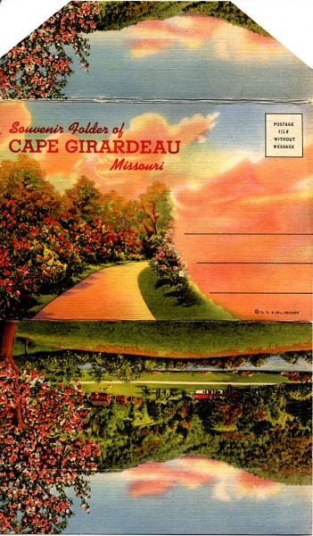
 I’m always looking for Cape memorabilia. I think I picked this Souvenir of Cape Girardeau postcard packet at Annie Laurie’s Antiques on one of my recent visits. It could have been mailed for 1.5 cents (without message) when it was new. (Click on any image to make it larger)
Sold at Strom’s News Agency
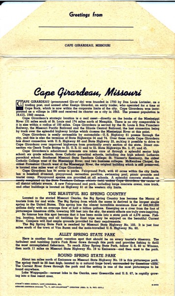 There’s a tiny note that says Strom’s News Agency, Cape Girardeau, Mo., on this sheet that has all kinds of factoids about Cape. I’m going to guess the information dates back to the late 20s or early 30s.
Bridge, bluffs and steam boats
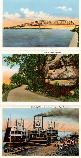 The Mississippi River Traffic Bridge opened to traffic Aug. 22,1928, so this had to have been published after that.
The rock bluffs have me guessing unless they are on the stretch on South Sprigg south and west of the cement plant. I can’t think of any other bluffs that are that close to the highway on The Kings Highway. I’m not even sure that South Sprigg carried that moniker.
Someone much more ancient that me will have to come up with the last time three steam boats docked on Cape’s riverfront.
Is that the KFVS tower?
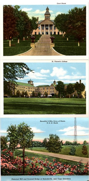 These postcards were hand-colored, so the artists had to make assumptions. Unless the facades changed, both the Common Pleas Courthouse and St. Vincent’s College were made of red brick.
The only radio tower that I can think of between Cape and Jackson was the KFVS Radio tower that I photographed in 2009. The one on the postcard doesn’t look like it’s on the crest of the hill but the perspective might be off.
Burfordville, Arena Building and SEMO
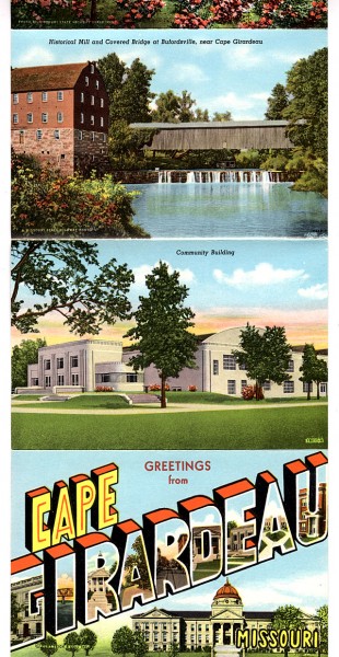 The Bollinger Mill and Covered Bridge at Burfordville looks pretty much like when I photographed them last year.
The Arena Building looks pretty much the same, too, but this was years before the Radio-Active Girl Scouts showed up there.
St. Vincent’s, Marquette and SE Hospital
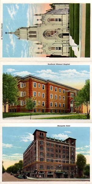 Southeast Hospital certainly has changed a lot since this was taken.
The Marquette Hotel looked pretty close to this in the 60s when it was in the background of a fender-bender I covered at Broadway and Fountain. The artist missed on the color of the facade, though.
St. Vincent de Paul Catholic Church has red brick in the real world, too.
St. Francis Hospital long gone
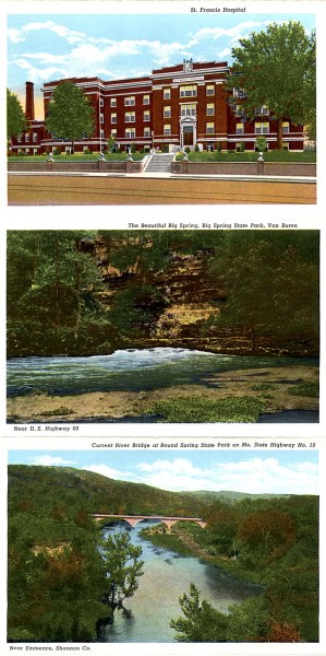 St. Francis Hospital was torn down in 2000.
They must have run out of things to show in Cape, because the rest of the images are from around the Big Springs region.
Curt Teich & Co.
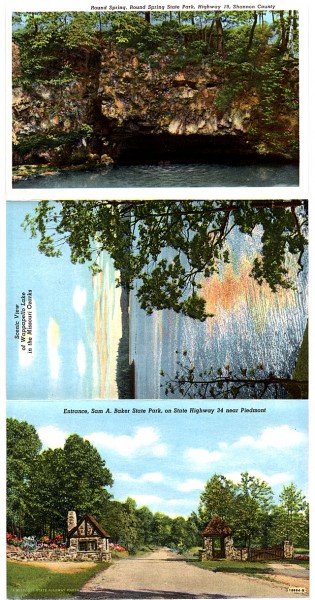 As a photographer, I’m pretty careful about appropriating photos that others have taken because I don’t like mine to get ripped off. In tiny, tiny print there was a note that the Souvenir Folder was © Curt Teich & Co. Figuring the copyright had probably expired – or the company probably had – I Googled the name.
I had seen this style of card over the years, but I didn’t realize exactly how many the company had produced. There’s a whole collection of them that includes images of more than 10,000 cities and towns.

Ken — The radio tower certainly was of one of the KFVS towers. Over the years, there was a series of towers out there north of town on what was then State Highway 25.I believe that as radio technology changed, the towers were changed. I even remember two towers with a wire between them. As for the bluffs you ask about, could they have been on Old Dutchtown Road, what is now highway 74. I’m not sure of that but it is a memory that there were bluffs there — as there were elsewhere.
Ken, I actually remember this postcard packet. It was kept in the drawer of a side table in our living room when I was growing up. I don’t know if one of my parents bought it to remember their home town or if it was sent to them and they saved it out of nostalgia. The pictures brought back vivid memories – both of the packet and of my childhood spent in Cape during every vacation and summer.
Hi Ken,I have several of these post cards! They are all nice!Remember all these places as they were, before being torn down and rebuilt! Used to be a Ward Clerk at Southeast Hospital in the 50,s. Now the hospital is all the way down what use to be a hill! And from Cape to Jackson was only a two lane with roses planted along the left side of the road. A litle white sign said Cape Girardeau, Mo City of Roses.A lot of things have changed and grown some but Broadway still seems awfully narrow !
Ken, have been enjoying the daily posts! They bring back lots of memories.
I especially enjoyed todays post of pictures of the 10 mile rose garden between Cape and Jackson. The widened road is great for traffic flow, but it hasn’t been so long ago that the trees still arched over highway 61 just up the hill from ‘the turkey farm’ (where now Style Stop and Safe Harbor Thrift Shop are now).
I think the “rock bluff” pic may be at Cape Rock looking south. At one time Old St Vincent’s Church was covered with stucco. Great trip down memory lane. One of the funniest local post cards I’ve seen had a picture of a local funeral home. What would you write on that….Having a great time, wish you were here?
It said the photo was taken on Kings Highway, which normally refers to U.S. 61 El, Camino Real. That doesn’t pass anywhere near Cape Rock.
I couldn’t read the small print. Maybe it’s along Boulder Crest which is now just off Kingshighway. I know the southern end of that stretch was changed and the Naeter home had an old entrace that’s gone now.
I was at an antique show in Cincinnati many years ago and stopped off at the post card table. One of the postcards was a “greetings from Cape Girardeau” card with a picture of the Marquette on it. Since it was from Cape to Cincinnati and I was from Cape and in Cincinnati and it was mailed on the date of my birth, I bought it. Still have it somewhere.
Ken.
The kfvs tower in the picture use to set in the field that the new Bowen engineering building was built. The old building stood with it’s back to the park fence. One of the concrete anchors still sits in the corner of the county park south. I worked at kfvs in 71-74 and had to help mow there in the summer. I was class of 1972
Oscar may have paid for the tower, but Ralph always claimed he built it – every bolt and nut.
In the book “Cape Girardeau Biography of a City” by Snider & Collins there is the exact picture of the three steamers called Bald Eagle, Tennessee Belle, and Cape Girardeau. There is no date for the picture in the book but in the Southeast Missourian on June 14, 1924 there is an article entitled “Levee Here Is Busy Place This Morning” describing the three steamers being tied up at one time. I don’t know if that was the last time three steamers were there at one time.
What a great piece of memorabilia. Our family had one too but don’t know when it disappeared. Some thoughts-the four lane highway sits closer to the tower than in this picture. I believe the rocks in the picture may have been removed by Federal Materials when they took off the hill at S. Sprigg and Hwy 74 years ago. It was always my understanding that the picture was shot in that area. At one time it was Hwy 61, El Camino Real Highway. Thank you Carolyn Seabaugh for identifying the three steamers. I have seen the photo before and knew one of them was the Cape Girardeau but didn’t know the names of the other two. Thanks to all-I enjoyed your comments.
Ken, I used to go down to the river on Sunday and sell papers on the boats tied up there, and I HAD 2 & 3 BOATS AT A TINE TIE3D UP AT the bottom of BroadwAY HILL more than once!
Those bluffs sure look like the one’s down below the cement plant and that highway was the major route south out of Cape when I was a kid there.
Joe Whitright ’45’
Hi Ken, I really enjoy your posts, and have been meaning to comment sooner. I used to live on sheridan dr. across the street from john, marty, and your wife. John and I were friends since the fifth grade at Lorimer School. We used to take peggy his beagle up in the field at the burroughs farm. Stan whitson was the caretaker and we used to ride the horses, and fish in the pond. I am sure he will remember the time he cut his elbow on the old car hood that we used as a sled up at the field at Whitsons (As we used to call it). It has been a lot of years and seeing pictures of them brought back a lot of memories. Tell everyone that Keith say’s hi and I wish everyone well.
Thanks for checking in. I’ll have to have Lila poke John. Getting him to read his email or this blog takes an act of congress and you know how efficient THEY are.
If you put John Perry in the search box at the top of the page, you’ll find him held up to scorn and ridicule numerous times.
Did you see the piece on the Burrough Farm I did?
The bluffs in the picture are still extant. The location is along South Sprigg Street, approximately 1500′ east of the former location of the Viaduct Court Motel and service station. They can be seen quite well in the Bird’s Eye View on Bing Maps.
The reason the scene looks a little different now is that the roadbed was widened and the curve eased sometime in the late 60’s/early 70’s. That road was part of the main path out of Cape to the north and to the south and southwest since the days of Don Louis Lorimier and was known as El Camino Real, literally translated from Spanish as The King’s Highway.
The old Cape Girardeau Railway (Louis Houck’s first railroad) paralleled the old King’s Highway up to St Vincent’s Seminary. This rail line went through a succession of name changes through the years and finally ended up as part of the St Louis – San Francisco (Frisco) system.
The picture of the bluffs should be attributed to Kassel’s Studio of Cape Girardeau; http://www.semissourian.com/blogs/flynch/entry/45781
Ken, I did see the piece that you did on burrough’s farm. I visted my sister about 5 years ago in chaffee, and drove all through cape. I could not believe how much it had changed. My dad owned the Texaco (Carl’s Texaco) on Morgan oak by the ST. Vincent Seminary, and we worked on vw’s. He worked for Allgood’s VW or it might have been Cape VW by the mid 60’s. He left Cape VW and went into business at the Texaco. The piece that you did on backyard’s and baseball was great. Alex’s last name was Harris, and Donna and Bill (Red) Snider’s son was named Dallas. I lived next door to them and across the street from John, at 316 Sheridan.
Hey Keith,
How you doing? I alo enjoyed the article on backyards and baseball. We played alot of ball on that field. Mom still lives there on Good Hope. Dad passed away 15 years ago. What great memories from our old neighborhood. I knew Lila , Marty, and John and all the Snder kids.What a time we had. Lila used to give me tickets for Central’s football games…if she knew the right ticket color for that game.
Thanks Ken for the article.
Hey Keith,
I just read the blog on the ball field behind my mom’s home on Good Hope. Mom is still living there. My dad passed away some 15 years ago. Those pictures brought back a lot of great memories from our neighborhood. I knew Lila, Marty, and John and the Snider kids… Thanks Ken for the article on the ball field.
PS Ken…Lila used to give me tickets to Central’s football games. All I had to do was to find out what color tickets they were using that night….
Alex Harris
Thanks for another trip through Old Cape Girardeau when things were much more simple and the landmarks were, oh, so beautiful! Everytime I drive from Cape to Jackson, I can’t help but wish that the 10-mile rose garden was still there and I’ll never forget the first time we drove under the the trees that arched over the highway, especially when they were snow covered. So beautiful. I wouldn’t mind progress as long as it didn’t have to do away with all the beauty that “gets in the way”! Thanks Ken.