Licking the Arkansas Arch

Jessica Cyders at Gateway Arch 11-04-2013_9935When Curator Jessica made her initial pilgrimage from Ohio to Missouri last December, I convinced her that every first-time visitor to St. Louis’ Gateway Arch has to lick the stainless steel icon.

She was a mere child of 29 at that time, and gullible.

Not falling for it at the state line

Jessica Cyders at MO - Ark arch 10-31-2014_4265
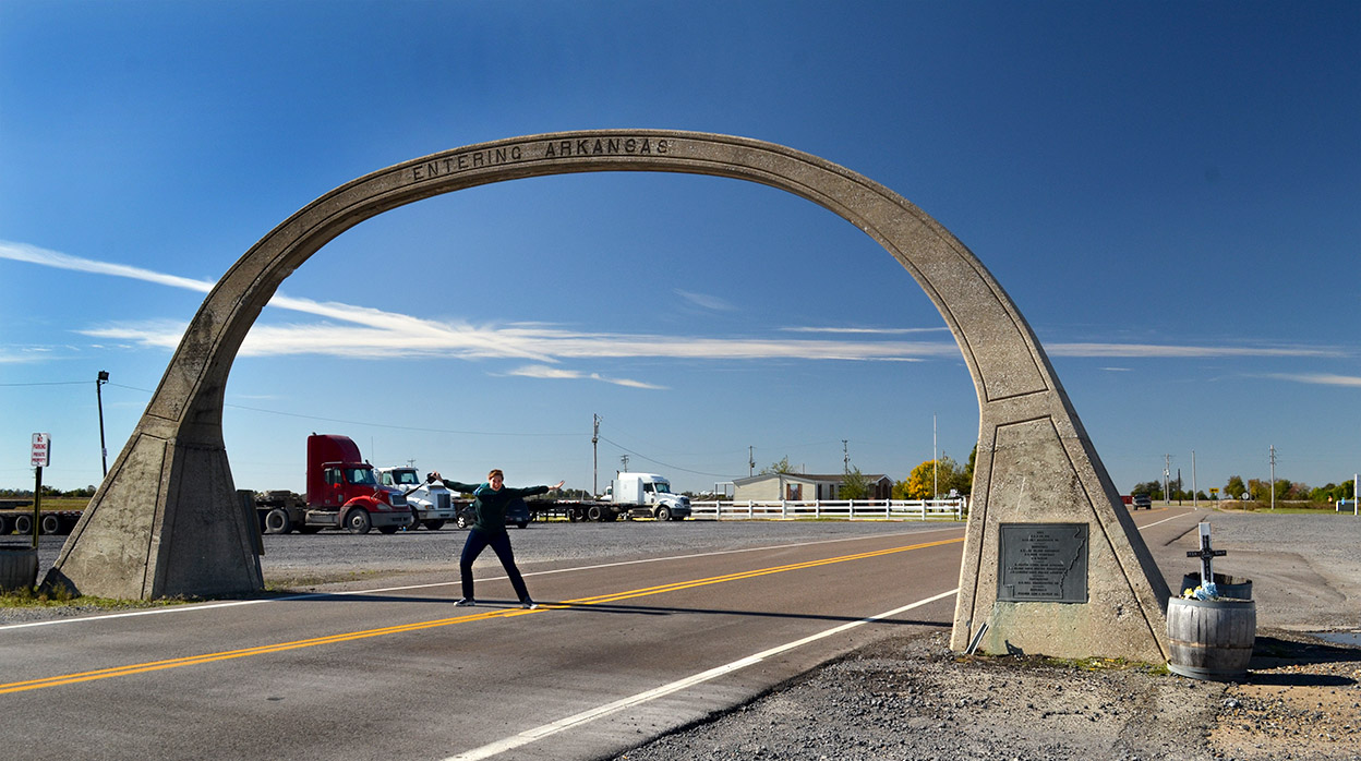
When I asked David Kelley of Steele, Mo., if the old concrete arch over U.S. 61 at the Missouri – Arkansas border was still standing, he said, “Yep. It’s still there. It’s only eight miles away, let’s go see it, then go down to the Dixie Pig in Blytheville for lunch.”

U.S. Route 61 is the official designation for the highway that runs from New Orleans, past Memphis, past Cape Girardeau and St. Louis, ending up in Wyoming, Minn.This section through Arkansas was once a dirt trail called the North-South Road, and was in such poor shape that it might take as much as a full day to cover 15 miles.

Highway 61 called the Great River Road because it parallels the Mississippi River a good part of its run. It also answers to the name “Blues Highway” because of the path it takes through Blues country.

Now that she’s put 30 birthday candles in her back pocket and done several thousand Steinhoff Road Miles, Curator Jessica is older and wiser. She wasn’t falling for the old Lick the Arch trick twice. She did agree to risk death by posing under the arch so you could get an idea of its scale, roughly 15 feet high and 20 feet wide at the base.

Almost a lick

Jessica Cyders at MO - Ark arch 10-31-2014_4267I didn’t realize until I was editing the photos that she DID fake an almost-lick for the camera. I guess that’s close enough.

The arch was created by the Mississippi County Road Improvement District in 1924. Check out what the National Registry of Historic Places says about the arch and what Arkansas highways were like in the first quarter of the 20th Century. It’s a fun read and will make you appreciate modern roadways.

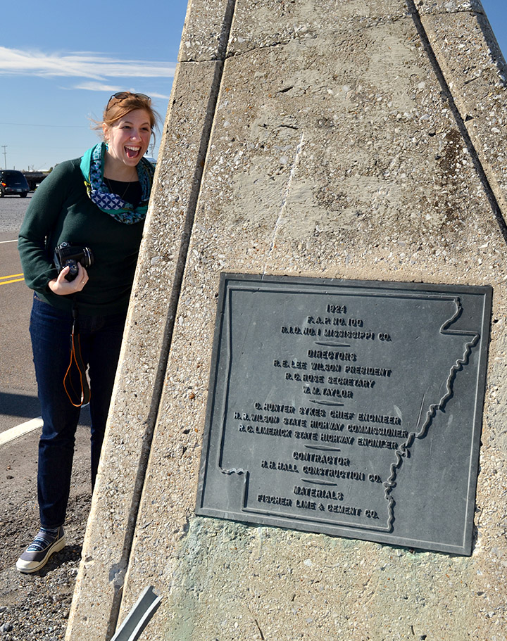
I love this part: The location of the arch on the directly south of the Arkansas-Missouri state lines had a somewhat strange economic effect. Highway 61 runs primarily north to south, but at the state line the road runs east to west for a distance of approximately one-half of a mile. The state line is located directly north of the section of  highway.

A lower gasoline and cigarette tax in Missouri led to a concentration of businesses on the north side of the highway. At one time there were as many as fourteen service stations lined up along the “line”. Along with the service stations came several nightclubs and small gambling houses. The area around the arch became known as “Little Chicago” because of the type of activity that went on there. A long-time resident of nearby Yarbo, Arkansas, once said of the arch, “It was a good place to go while the wife and kids were in church.”

Click on the photos to make them larger.

Lights in the Night

Sugar Tree Ridge Cemetery 11-01-2014_4329Mother, Curator Jessica and I took off for Steele this morning – eight miles from the Arkansas border – to photograph a Bootheel farmer I met at the Altenburg museum last week.

No journey ever takes us from Point A to Point B directly back to Point C, so we wandered around in New Madrid County for a bit, then meandered all over places that I’m not sure even the Lady in the Sky who lives in my GPS has ever heard of.

Let me explain the division of labor here: my job is to drive and keep us from getting killed by wayward 18-wheelers. The job of the Road Warriorette is that of Navigator, responsible for directing the Driver toward food and lodging (and, as we will find later, Natural Breaks).

We left New Madrid with the sun high in the sky and decided to find some roads that skirted the Mississippi River, some of which must have followed the paths of drunken cows.  Shortly after I pointed out that we had already been through a particular intersection at least twice, we ended up going down a road aptly bearing a sign, Dead End, that led to a well-kept Sugar Tree Ridge Cemetery.

With the sun going down on one side and the moon coming up on the other, I suggested that Mother might want to start rationing the cookies we had brought along: “This might be a long night.”

A farmers work is never done

Farmer in field 11-01-2014_8246We weren’t the only ones picking our way though the dark: we spotted lights on farm equipment dotting the countryside.

We hadn’t seen a car behind us for an hour, but the moment I stopped in the road to take this photo, I heard the whizzz of one passing us. I’m glad he had room to pass: most of the bridges out there were labeled “One-Lane Bridge.” They didn’t bother to note that the road wasn’t much wider than the bridge.

A natural break

Truck turning off I-55 11-01-2014_8261With 43 miles to go, my Navigator gently suggested that the trip would be much more pleasant for her if we would stop at the next convenient place for her to take, as they say in the Tour de France, a “natural break.”

While waiting for a chance to get back on I-55, we spotted this one-eyed truck coming toward us. Navigator Jessica asked if I had ever played “padiddle.”

Having led a sheltered life, I had to confess that I had heard the phrase, but didn’t know exactly how to play it or exactly what it was. My navigator demurred providing details.

Basic rules of Padiddle and Pedunk

Google being our friend, I was enlightened by the Urban Dictionary: A game in which you look for cars with headlight or foglight out (padiddle) [also spelled pididdle] or tail light (pedunk) and call it out. When someone correctly calls a padidle or pedunk, all members of the opposite sex present must remove an article of clothing.
Example: Padiddle! You have to take off your shirts. 

Our trip from Missouri to Ohio has just become a lot more interesting.

As always, click on the photos to make them larger. Alas, there are no padiddling photos available.


Happy Hallowthanksmas

Benton Boomland 10-31-2014Mother, Curator Jessica and I had a productive day roaming around southern Illinois and Southeast Missouri. With the late afternoon sun taking a dive to nap time, we decided to head home from Cairo by way of Charleston so my Ohio curator friend could see some of the buildings there.

This would be a good time for me to knock off Boomland, I told my passengers. I’d never been there, but it seems like it would be the kind of place a lot of my readers would enjoy.

We missed the Charleston store, but the signs said we would find another one at the Benton exit. I had to explain to Jessica about the Benton Hills.

Halloween and Thanksgiving

Benton Boomland 10-31-2014What I took to be a Halloween pumpkin and some corn, which might symbolize, Thanksgiving were by the front door.

Christmas trees on Halloween night?

Benton Boomland 10-31-2014In at least two display windows were Christmas trees. Christmas trees!!!

On HALLOWEEN night.

I don’t want to say this is rushing the season, but I was always taught that it was good etiquette to wait until the corpse got cold before asking the widow to dance.

P.S. I didn’t coin the phrase “Happy Hallowthanksmas;” someone else did, and Wife Lila passed it on to me.

P.P.S. Boomland is a fireworks joint at heart, so I won’t blame them for rushing the 4th of July.

African Methodist Church Cemetery

African Methodist Episcopal Church Cemetery 10-28-2014When I did a post about the huge quarry just south and west of Old Appleton in July, Dennis Mize and Tom Mueller mentioned that there was a small African American cemetery located near the quarry.

On the way south from dropping Wife Lila at the airport in St. Louis, I decided to check it out.

They were right

African Methodist Episcopal Church Cemetery 10-28-2014Dennis and Tom were right. Just west of Hwy 61 on KK was the African American Church Cemetery marked by a sign that listed some of the names and family histories of those interred there.

Alexander Hull died in 1898

African Methodist Episcopal Church Cemetery 10-28-2014Alexander Hull was born in 1892, and died in 1898, before his 5th birthday. His stone was one of the easiest to read. It looked like it had been reattached to its base recently

Graves at quarry edge

African Methodist Episcopal Church Cemetery 10-28-2014When I strolled down the hill into a wooded area, the quarry popped into view. This grave was almost at the edge of a dead (pun not intended) drop-off. I could only wonder how many bones had been crushed along with the limestone over the years.

A huge hole

African Methodist Episcopal Church Cemetery 10-28-2014I’m going to guess the stone walls rising above the water are at least 75 to 100 feet tall. Apple Creek runs between the quarry and the farmland in the background. It must have been a challenge to keep ahead of the water when it was an active quarry.

Didn’t feel like exploring

African Methodist Episcopal Church Cemetery 10-28-2014I didn’t spend much time walking around that area of the graveyard. The ground sloped down toward the quarry and some of the overburden didn’t look stable. I had no desire to end up as a splash or worse.

Nature’s color palette

African Methodist Episcopal Church Cemetery 10-28-2014The late-afternoon sun and fall leaves made it a place of quiet beauty. A quick Google search didn’t turn up much information about the cemetery or the church it served.

Blasting area

Old Appleton Quarry 10-28-2014I’m sure the cemetery is a lot more peaceful since it’s neighbor, the old Appleton Quarry, has ceased blasting.

Quarry from the air

Aerial Old Appleton Quarry 04-17-2011This aerial photo taken in 2011 clearly shows how the quarry left a little plug of land where the cemetery is located. It’s much like how the cement plant quarry has mined around the Natatorium.

Click on the photos to make them larger.