

People who whiz up I-55 to get from Cape to St. Louis in about two hours never give a thought to U.S. Highway 61 that runs from the lands of ice and snow to New Orleans. Roads used to be known by names, not just numbers. Route 66, running east and west across the country was known as The Mother Road. North-South Highway 61 was El Camino Real – The King’s Road.
Going through Cape, it’s still called Kingshighway, and I grew up on Kingsway Drive, which parallels it.
Old U.S. 61 was a hilly, curvy, narrow road. Heavily-laden underpowered trucks growling up the steep hills would back up cars dozens deep. Eventually, someone would get impatient and try to pass, resulting in a grinding head-on collision that left dead scattered all over the roadside.
CB radios were decades in the future, so truckers and savvy drivers learned to communicate with their lights and hand signals to warn of speed traps and hazards ahead. Flashing headlights or an arm extended palm-down and waved in a patting motion meant “SLOW DOWN!”
Welcome rest area
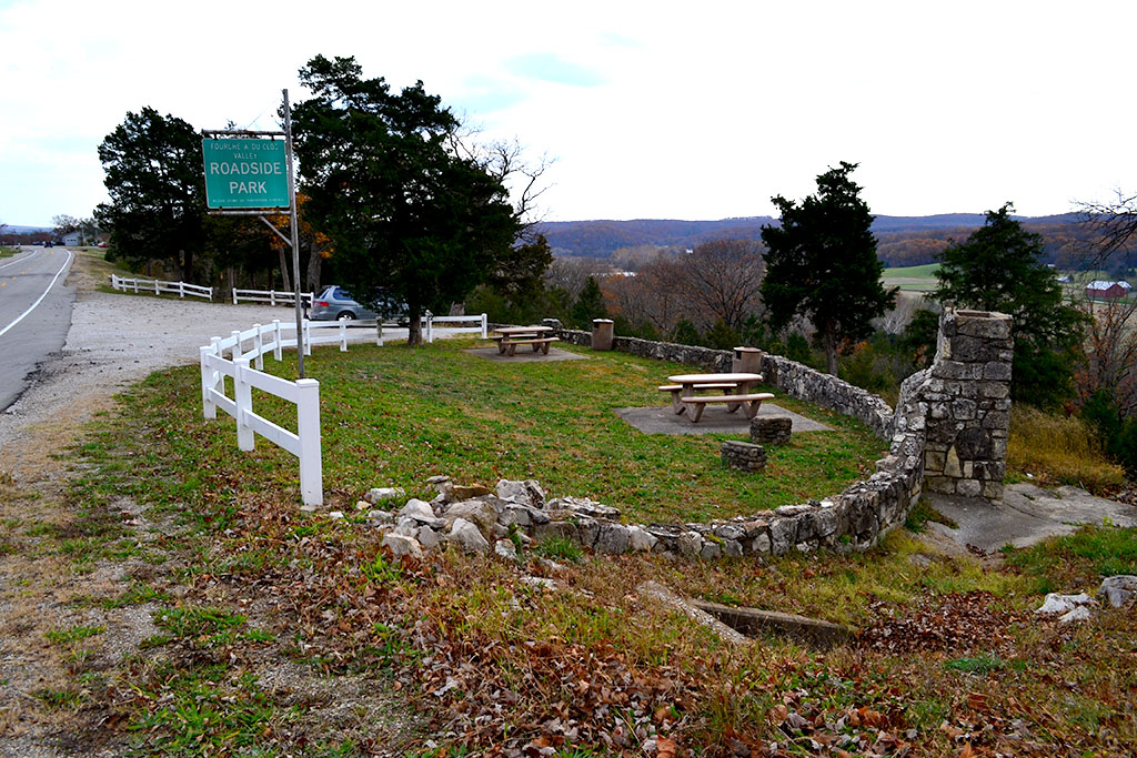
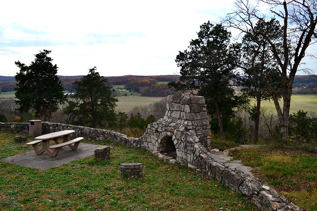
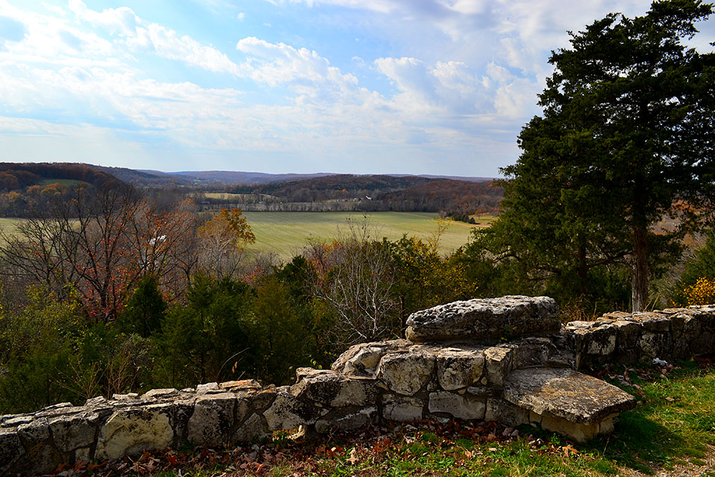
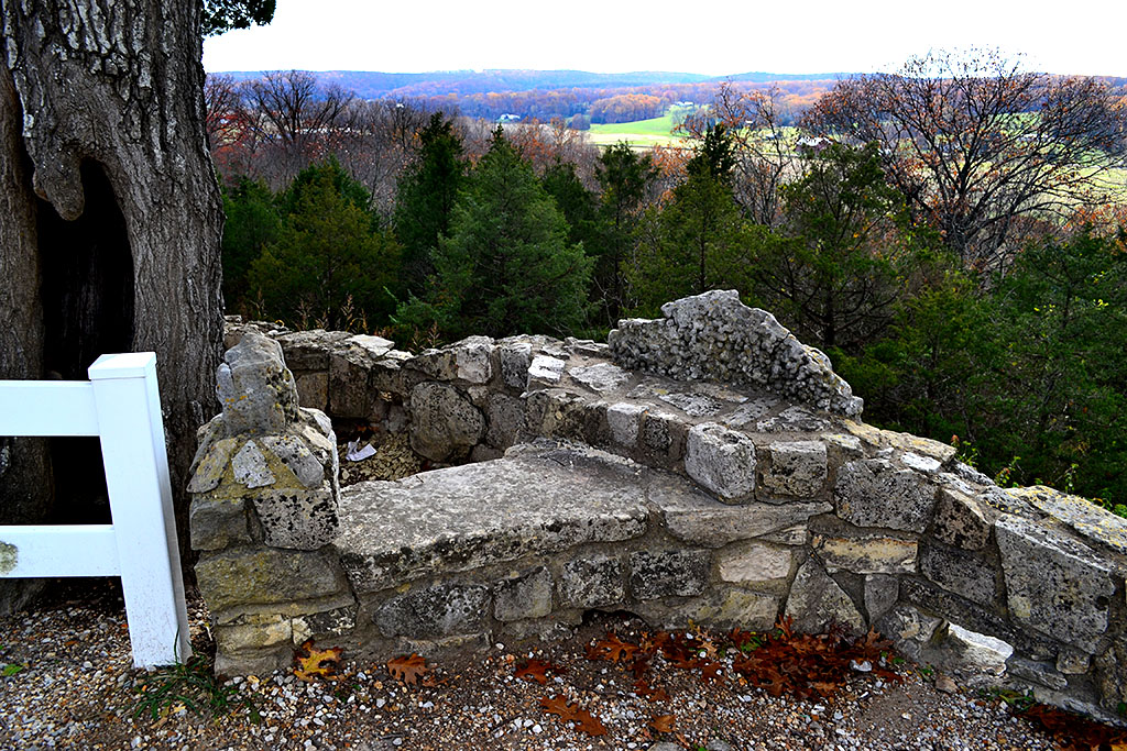
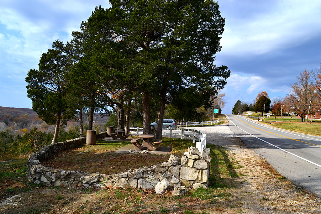
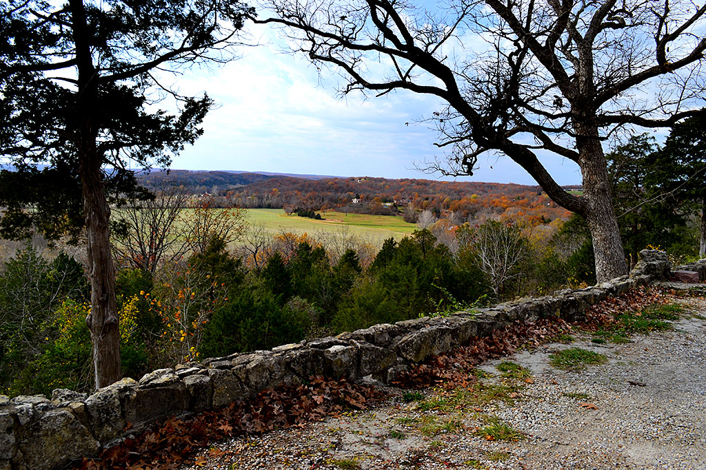
 About halfway between Cape and St. Louis, north of Bloomsdale and its Dew Drop Inn, was the Fourche a du Clos Valley Roadside Park. It had a spectacular view across the valley, picnic tables and a stone grill that’s still there. It has every feel of a WPA project, but I couldn’t find any markers around to confirm that. It was a great place to pull off to let your car and your kids cool off. I don’t think we ever passed there without stopping.
There were no rest facilities at the rest area, so what you might take as little white carnations all over the place when you looked over the stone wall and down the hill were actually tufts of toilet paper. Not all of the things in the Good Old Days were all that great.
I’m happy to report that there were no carnations visible on this visit.
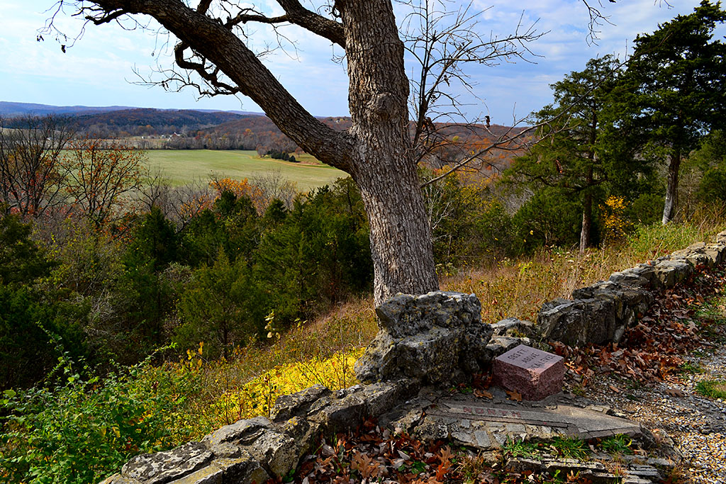
583 feet above sea level
 In case you were confused about which way you were going, there is still a concrete arrow that point NORTH. Next to it is a stone that proclaims that you’re standing 583 feet above sea level.
U.S. 61 has been improved

U.S. 61 has been improved. Cuts and fills have made the grades not so steep; the road has been widened and most of the through traffic stays on the Interstate, so it’s not the white-knuckle drive you might remember as a kid. I actually enjoyed my cruise south along the new old road.
Fourche a du Clos Valley Roadside Park photo gallery
Take a load off and click on any photo to make it larger, then click on the left of right side of the image to move through the gallery.
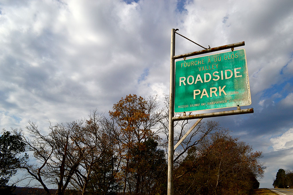
Just did a quick translation on the internet and it comes up with “Fork has Field”.
Anyone out there who speaks French who can verify (and maybe explain) that?
My grandmother’s family name was DuClos, and they lived in the St. Genevieve area in the early 1800’s.
Mary Wilcox, I wonder if we are related, Duclos are also my folks and I carried the updated name of DeClue before marrying. I was so happy to find the post on this roadside park while researching the old folks.
Thisa great place to visit with wonderful view off to the south of the river and its valley. I stop here on almost every trip to St. Louis I make. Exit of Old US 61 at Bloomsdale hit old 61 and turn left or north and go to the top of the hill. Truly a great spot to stop and smell the roses…
Roses are OK, but stay away from the carnations.
What memories this brings back, Ken. Before this was Highway 61, it was State Highway 25 and before the trucks slowed you down as you describe, it was mule drawn wagons. Back during WWII and shortly afterwards, it seemed like every farm along Highway 25 had two or more mules or draft horses in the barnyard, animals that were still used for pulling the plows, reapers, rakes, harrows and other implements of the farms that bordered this road. Also, it was a time of gasoline rationing, another reason that so many mules and draft horses were still present.
The worst time to travel Highway 25, as my father once learned, was on a Sunday morning when many farmers were coming and going to church in wagons or buggies drawn by these fine animals. You should have seen the lines of cars backed up on those mornings!
Like your family, ours always stopped at beautiful Fourche a du Clos Valley Roadside Park on our way to Cape or St. Louis. Sometimes Mom brought a picnic lunch we ate there but other times we had the hamburgers and chocolate malted milks served at a particular truck stop service station in Perryville that was a favorite.
I need to remember to take this route again the next time we head for Cape.
OK, you win the Old Coot award of the week. Even I can’t claim to have been delayed by mules on Highway 61/25.
One can tell the comments left here by members of the younger generation. They, including you, Ken, refer to this road as “Old 61.” No. It is “Old 25.”
Guilty. I’m just a young whippersnapper.
The correct translation would be Fork(Fourche) of(a) DuClos(DuClos). DuClos is a French surname. The valley is named for a French settler that occupied land at a stream fork in the valley.
You had better get a new map. US 61 goes north from St Louis to Davenport Iowa and eventually to Minneapolis, Minn. To get to Chicago from St Louis before the days of Interstates you would have taken US 66.
Thanks for pointing out my serious brain fart. It’s probably because I never took Hwy 61 north of the Missouri border. In fact, it’s likely I never ventured north of St. Louis on it.
I’ll change the original story to reflect something close to reality. Chicago is cold enough. I’d hate to have someone end up in Minnesota because of something I wrote while half-asleep.
I don’t know who is gonna read this one day, but I live on Carron road, the road that runs alongside the river in the valley, I was glad to see there are people from different generations who have agreed how beautiful it is here.
61 used to go all the way to the Canadian Border or very close to it. I have traveled the southern portion many times. When Sig pledges kidnapped actives and took them to New Orleans to party! what a great route. but never took the northern trip. on my “Bucket List” along with the last two states I haven’t visited North and South Dakota.
Ken — I don’t know what is going on but when I click on any of your links in any of your recent emails announcing a new comment I only get to the first comment. None of the additioanl comments including my own show up on my screen. Paul
I’ve stopped by there a few times in the recent past to show family unfamiliar with US 61. Traffic to St. Louis on Sundays was so heavy with people returning to St. Louis to go back to work for the week. Friday night was a race back down to the bootheel and Arkansas for the weekend with the family. Dad never liked having anyone in front of him so there were times we would have to close our eyes while he passed people on the hills and curves of that old road. Thanks for taking those pictures, they bring back so many memories.
When I was in school in SEMO in the 60’s and 70’s, anyone who drove to St. Louis knew at least a part of Highway 61. There was a 30 mile stretch you had to take north of Fruitland because unless you went up to St. Louis on the Illinois side, it was the only way to get to the interstate. That 30 miles of road was fraught with peril. The narrow road itself, the big trucks and the farmers who drove too slow, the drunks, poor lighting, dealing with the local traffic, and the speed traps, especially in St. Mary etc. etc. etc. They loved taking speeding money from college kids. I used to hitch hike to St. Louis on that 61 stretch and once I begged the country singer Bill Anderson for a ride in his bus. He was stopped at a little cafe eating one rainy Friday evening in the late 60’s. He said no ride.
I can’t say I miss that drive and haven’t been on 61 in over 35 years. I’ll just let others enjoy the drive, if they can, because I wouldn’t take that road again unless I had to.
I share my brother Paul’s vivid memories of this road. I was the little sister in the backseat calling out the names of each little town to hurry the trip to Grandmother’s house…..over the river and through the woods.
I have memories of Hwy 61 and it was hwy 25 before 61. In the 60s I would head to school in Central Missouri on Sunday afternoon and be car #25 in a line of 35 cars following a large truck. 25/35 mph uphill and 65 mph downhill, here would come an idiot passing everyone on a curve or blind hill! You had to let him in or be part of the wreck.
Later as I was then dating my bride of 46 years, I would drop her off at her home by the airport in St Louis after a date and continue on home to Cape. It would be midnight so I would roll down my windows of my ’55 Chevy and sing, that would keep anybody awake! If it was winter, I just turned the heater on and keep the windows down.
I wouldn’t recommend it today but in the 1960s we also used Hwy 61 to Hwy 51, across the Chester Bridge, go north on Hwy 3 to Red Bud. Take Hwy 159 north out of Red Bud to Belleville then Hwy 15 into downtown East St Louis across the King Bridge to downtown I-70. It was faster, safer and less traveled.
I believe the roadside parks were actually built by the CCC, Civil Conservation Corps. That was part of the FDR recovery programs like WPA and it put young men back to work and kept them out of trouble. It was better to put them to work doing something useful than to keep them up in prison. As a kid I remember seeing the CCC boys working to develop the road side parks on Kings Highway, the 10 mile rose garden between Cape and Jackson. They also developed state parks throughout the country. I think they built the parks around CApe Rock Drive, David Middleton
I love all this talk about Hwy 61. I, too, remember all those Hwy 61 trips to St. Louis and home again.I think it was a 3 hour road trip one way in those days, as oppose to the now existing 1 1/2 – 2 hour trip on I-55 from Cape.
It’s a nice feeling that I now live on Hwy 61 just as you reach the northern border of city limits leaving Hannibal, MO (another great old river town). I certainly feel connected to my first home. 🙂
Wasn’t there a HUGE rocking chair outside a roadside establishment either in St. Marys or Festus? My memory fails me where, but I can still see that big rocker in my mind.
I more hwy 61 memory. My first driving lesson was on Hwy. 61 going north through Fruitland to Oak ridge. My dad and I were on our way to visit my brother and his family who lived on the Cargle farm in Oak Ridge. Dad pulled off the road and said…today you will learn to drive and I took the wheel. I can remember vividly his instructions and my terror of crossing that center line. Fortunately, we made it safely. Today, I live in baton rouge, Louisiana and hwy 61 is known here as Airline Hwy.
As to the translation of La Fourche à Duclos, Wikipedia.org entry for Bloomsdale, MO says it means “Fork of Duclos.” Asking Google to translate French to English the word “Fourche” results in the word “fork.” and “à” results in the word “at” and “du” results in the word “of” and “Clos” results in the word “vineyard- especially a walled vineyard.” So La Fourche à Duclos comes out to “Fork at of vineyard.” Another reference reported the creek was named for a pioneer family that homesteaded land at a fork in the creek. That family was either named Clos or Duclos. I wonder if anyone in the area has knowledge of a Duclos family or their descendants. Their descendants would possibly be named DeClue. Census takers often changed the spelling of family names. The question and answer session at the door might be like this: Census Taker: “What is your name?” Resident: “Duclos” (which in French is pronounced D’clue). CT: “How do you spell that?” R: “I don’t know. I can’t read or write.” The census taker then would spell it DeClue (the way it sounds). Like the census taker, the local notary public, (back then) wrote letters for people and did any documenting residents needed. They too would change the spelling of names as they wrote letters, spelling names the way they sounded. The only correct recording of the name Duclos I have found was by French Catholic Church priests. There, births and christenings were accurately spelled. My parental grandmother was a DeClue and the St. Joachim Catholic Church in Old Mines, Missouri has records of her ancestors with the correct (Duclos) spelling. Who knows? Maybe one of my distant relatives lived at the fork of a creek near Bloomsdale, MO!! Or maybe not….
Thanks for the history lesson, particularly about how names would be mutated.
Hey, the Duclos info here is interesting. The original people you mention with that name at St. Joachim church are my direct ancestors. Through family research all around this part of Missouri I see the word Fourche often used as part of a place name where the owner had a stone oven used in the smelting process connected to a local mining operation. Perhaps it also translates to Fork, I don’t know.
Ken Steinhoff… Census takers didn’t just mutate names. They also mutated ages. They were paid by the lines they completed, so completing an entry for a family that was not home was important. Thus, when a family was not home, they were not beyond asking a neighbor “who lives there and their names and ages.” Again, for a name change, a family who had the surname of Owen was changed to “Owens” when the neighbor reported, “the Owens live there.” The neighbor was giving the plural of the name to talk about multiple family members. The census taker entered that plural as the last name of the family. Josiah Owen became Josiah Owens. When asked the ages of family members, a neighbor guessing ages can cause a person’s age to not compute from one census to another. The census taker was not required to report the source of his information. Now you know some of the fun in genealogy research.
Hiway 61 goes all the ways to New Orleans, LA, and is part of the Mississippi Blues Trail!
https://en.wikipedia.org/wiki/U.S._Route_61