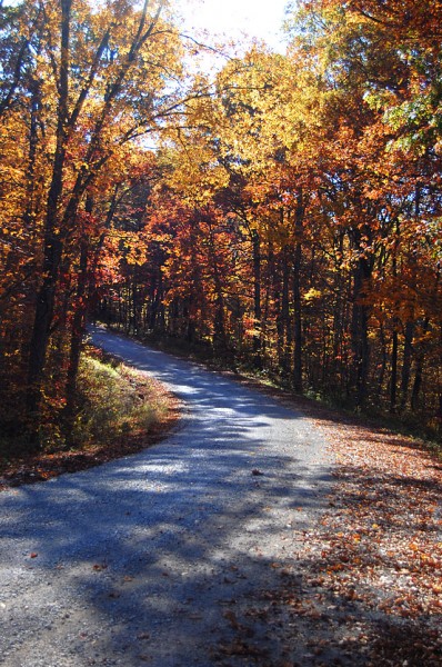
 Coming back from shooting the Tower Rock Quarry, Friend Shari suggested we go downtown to the Bluegrass festival. Rather than taking my normal route out of Altenburg, I said, “Let’s take the scenic route. That should drop us on 177 and we can go in from the northeast side of Cape.” (You can click on any photo to make it larger, by the way.)
“Let’s take the scenic route” would have been something I would liked to have said when we were dating, except that (a) I didn’t have my license yet and (b) Dad was a pretty good guy, but I’m not sure he, as designated driver, would have gone along with the idea. So, four decades too late, I’m married, in a minivan, in broad daylight, taking the “scenic route.” Somehow it just isn’t quite the same.
We went straight UP
I didn’t realize just HOW scenic it was. Shortly after turning off Hwy CC from C toward the Apple Creek Conservation area, we went straight up. I mean like waiting for the oxygen masks to deploy from the overhead storage compartment straight up. We were headed for the ridges.
See, back in the days before heavy construction equipment was even thought of, road builders didn’t have the ability to cut the tops off hills and fill in the valleys. You rode the ridges, which are generally pretty twisty-turny.
Shades of Wolf Creek Pass
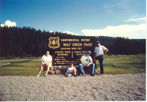 A line from Wolf Creek Pass, a C.W. McCall song about a couple of truckers with a load full of chickens who lost their brakes on the downhill side of the Continental Divide came to mind. “Well, from there on down, it just weren’t real purdy; it was hairpin county and switchback city. One of them looked like a can of worms; another one looked like malaria germs.”
I looked at the GPS and told Shari, “We’re fixin’ to come up on a curve that would let us touch our tail if this thing was just a little longer.” I forgot to mention that Hwy CC turned into CR 535, which is gravel. We hit on uphill stretch that was so steep that we lost traction and I thought we were going to have to back down to the bottom to get a fresh run at it. It WAS scenic, however.
Church at the top of the hill
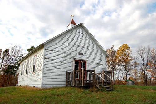 Finally, we hit the top of a hill where there was clearing. On the top of that clearing was a white frame building that looked like a church or a school house. I tried to make out a name, but couldn’t. It was getting late in the afternoon, so we kept plugging on.
Proctor & Gamble aerial
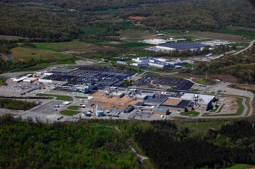 Eventually, we turned off CR 535 onto CR 525 and I saw on the GPS that we were getting closer and closer to the Mississippi River. Finally it dawned on me that we were coming into Neely’s Landing from the north. CR525 became Hwy J and hooked around the Proctor & Gamble plant. I had photographed it from the air in the spring, but didn’t have a clue how big it was until we kept passing gate after gate. That took us onto 177 like I had predicted. Eventually we made it to Water Street and heard some good music.
Let’s go back to the school
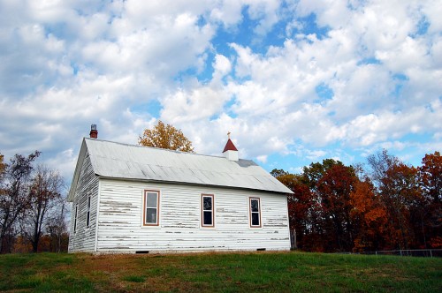 A couple of days later, I said to Mother, “Hop in the car. I’m going to see if you’ve ever been on this road before.” Unlike with Shari, we started on the south end of the road. She knew where Proctor and Gamble was, thought she had been through Neely’s Landing, but didn’t think she’d ever been up in the ridges around Apple Creek Conservation area.
I wanted to take a second gander at this building. It appeared to be in good shape. The paint was peeling off it, but it looked like a bad paint job, not neglect. There’s a chain link fence around the property that’s so new it still has the bar code stickers on it.
Looking through the window
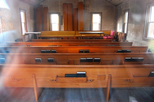 The windows looked like they had been replaced not long ago; the pews, which looked padded, appear to either be new or in extremely good shape. The floor looks solid and the walls have either been stripped of paint or they’ve been recently plastered or drywalled.
No name on the building
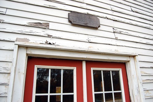 There’s a wooden plaque that looks like it might have contained a name at one time, but there’s no visible writing on it today.
Small cemetery behind church
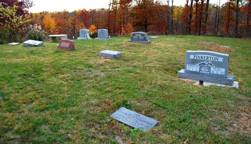 There’s a small, well-kept cemetery behind the building.
The gravestones are relatively new
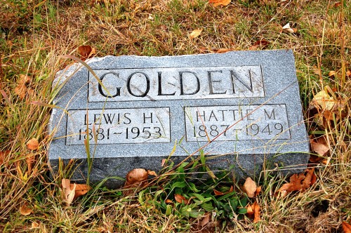 I didn’t spend much time poking around, but one of the oldest markers I saw was for a World War II PFC named Ralph Craft. He was born (it looked like) Sept. 6, 1925, and died Oct. 17, 1946.
This stone, which looks like it might have been chipped by a mower, only dates back to 1949.
Some markers are from the last decade
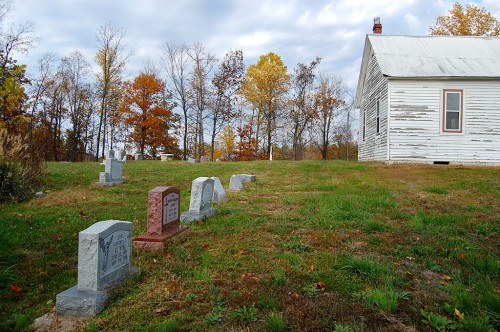 A large percentage of the makers are from the late 1990s up to as recently as 2010.
Restroom facilities out back
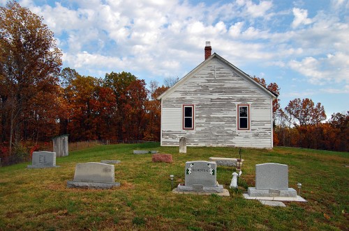 An outhouse serves as a restroom.
Child’s grave has surprise
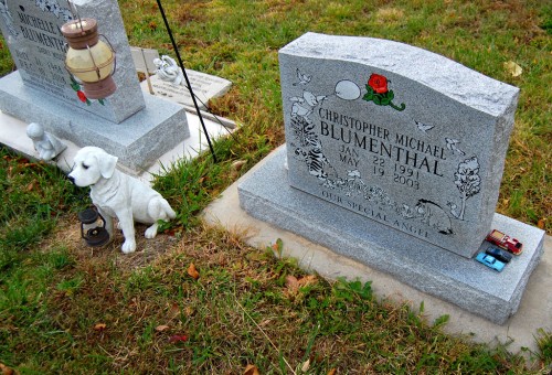 I always have a strong emotional response when I see a child’s stone in the cemetery. This one was particularly touching because of the toys on the right side of the stone. I don’t know if they are still there because there’s little traffic in the cemetery or if any visitors who do come this way respect what they stand for.
While photographing this pair of stones – a brother and a sister who died of unrelated causes – I thought something looked odd, but couldn’t quite place what it was. Then it dawned on me: the statue of the dog is holding a lantern. And, the bulb in the lantern was glowing in the late evening light. (You might even be able to see it in the photo if you look closely.) That’s when I noticed it was a solar light.
Blumental graves gave clue
Reader Keith Robinson was in town visiting his dad and stopped by. I was describing my mystery when he suggested we pull up Google Maps to see if we could spot the building. Indeed, it was clearly visible, but unidentified. Up the road a piece, though, was a marker for High Hill School.
I did a search of Missourian archives for High Hill and came up with some obits for several people, including Michelle Blumenthal. They mentioned interment in High Hill Cemetery. A couple of them said the deceased had been members of High Hill Church of God.
Michelle’s brother, Christopher Michael Blumenthal, died at 12 of complications from heart surgery in 2003. Dammit, it’s OLD people who are supposed to die, not kids.
So, it looks like the cemetery is named High Hill and the church might be as well, although I don’t know if it’s still a Church of God congregation. I don’t know if High Hill School still exists, either. Looks like another excuse to take the scenic ridge route.

Charming Photo Stories today. A Kansas City writer/columnist, Charles Guisewelle once told me, “Give them your heart and the reader will come.” You did that today with your cemetery photos and a child’s grave.
Judith Bader Jones
My mother’s family lived at Neely’s Landing for a time before moving to Moccasin Springs, now Trail of Tears Park. I don’t know much about Neely’s Landing yet. Her father’s name was James Johnson, her mother was Ella Malee Burns. My mother’s name was Mary Bell Johnson Yow Maupin. She passed away last December and is buried in Fairmount Cemetery in Cape. She was one of 5 children. The family was very musical, sang at churches, and even on the radio in the late 30’s.
i know that church very well. the red grave marker to the left of the one photo is my mother’s,hannah v cotner. next to her on both sides is my sisters pauline and virgina. i have a baby borther buried there as well as my grandparents mary and robert rumfelt.there are several pinkerton’s that are laid out there.
down the road a bit used to be a one room school called high hill school. grades 1-8. my mom attented it. at that time it was thought a women didn’t need any further education past the 8th grade.
the school is gone and the church became ran down until someone decided to repair it.cousins on the pinkerton side had the fence placed. my brother in law george came to attend it must have been virginia’s funeral? he was so impressed with how pretty that area was on the top of that hill he he told my sister he wanted to be buried there instead of texas.the hill where the church and cemetary is called united states hill..i think that is what the name is?
Thanks for the information. It’s truly a great location. Any idea how long the church has been there? I’m still surprised that most of the stones are fairly recent.
Can you still get back to the site of the old school or is it posted? Is there anything left of it? Foundation or anything?
I was looking at a Garmin Mapsource topographic map of the area. It shows High Hill School, but not the church and cemetery. The names of the hills aren’t shown. Looks like that ridge is about 500-550 feet high. Cape Rock, by comparison, is only about 375 feet high.
I have a map of the area that shows the High Hill church in existence in 1885 and an associated school in 1897. I also have a picture of the church as it appeared in 1994 before the restorations. The hill you described was probably United States Hill that required cars from the Model-T era to go up the hill in reverse because the gravity fed fuel from the gas tank wouldn’t flow to the engine otherwise. The hill was also a military overlook of the Mississippi River and cannon placement during the civil war. My ancestors helped settle the area in the 1820’s.
I have ancestors named McClard. My mother was Nancy South who taught at High Hill. Her mother was Edith Hockenberry who owned a dairy farm on the very spot where Proctor and Gamble is built. We may be related.
Hello Amy. Do you have the McClard genealogy book? It has all the McClards and shows Nancy being the Granddaughter of Minnie Mae McLard and William Capps and having children Hollie and Terry Johnson. I have pictures of Minnie and her parents. Give me a call (573) 382-2101 in Cape or McClard@live.com.
I just came across these msgs again. Was wondering if I could get the genealogy book. Is your number the same?
Lovely column. And solid research to find out what you did discover about the church’s name. And now your readers are helping out even more. Love it.
Thanks, Miz Anne. (Anne is a Texan transplanted to Florida and a bike riding partner if and when I ever get back down there.)
I feared that readers would get lost in that alphabet soup of road directions. I’m glad Darla, Dick and Stephen helped fill in the blanks. It seemed like I kept running into more questions than answers.
The story does go to prove that there’s no such thing as a wrong turn. If you keep your eyes and your mind open, there’s always something new to see.
Ken, Stephen and Dick confirmed the name that I thought was applicable to that area – United States Hill. I remember riding up from Neelys on that road some summer Sunday afternoon in a non-air conditioned car when I was much younger and the gravel road was not very wide and not as well maintained – it was a definite hill climb. My father remarked at the top that we were on top of United States Hill. There were fewer trees then and the view was inspiring!
I wonder if those are licensed A.A. Milne characters on the grave stone?
Cheers,
Matt
keith i couldn’t imagine how much gravel dust i swallowed through out the years riding on that gravel road. the dust..the sound of the tires on gravel.the heat..the bugs..then when we got to the cemetary there was always that last warning to us as children…”watch out for snakes”..LOL then to be told if we had to use the potty it was this old stinky outhouse with god only knows what is living out there and then the wasps nests! then back in to that hot car for the trip down the hill. my grandmother rumfelt lived in neely’s landing..her house is gone now.when the train would go by the whole house would tremble.
Ken – The Church in question is the High Hill Church of God located at Neely’s Landing Missouri. My Mother Hannah V. Cotner, sisters Virginia D. Cotner and Alma Pauline Rumfelt are interred there. as well as my Brother Anthony Eugene Cotner and my Brother-In-Law George Welsh. I have Aunts and Uncles and my Grandparents there also as well as many other relatives. The area is so beautiful in the fall when the leaves change colors and in the spring when everyting blooms and turns green – it just leaves you breathless! Such a beautiful area to spend eternity in. United States Hill is a very steep hill and as a child I remember holding my breath when we went downhill!! Not far from the Church buried deep in thick brush is probably the remnants of High Hill School. The school was demolished many, many years ago, but maybe the stone “footprints” are still there. I don’t believe anyone can get back in that thick brush now – would be dangerous. About a mile or so from the Church is another hill names Thompson’s Hill. That is also a steep hill and can be treacherous during inclement weather. Everyone buried at the cemetery is related in some way – sort of like a “family” cemetery if you will. Very beautiful and peaceful area. Thanks for “coming to the top of that hill”.
It IS a beautiful spot. Was there a community of any kind up there to support the church? Neely’s Landing is pretty far away by foot or by wagon, I would think.
It’s interesting how some news stories call it Neely’s Landing and the other refer to Pocahontas.
I may try to find the old school some day, but I think I’ll wait for after deer season. It would be just my luck to blow my nose on a white handkerchief and end up draped across some nearsighted hunter’s hood.
The closest communities were Hines Landing, Sheffield, Lovejoy and Crawforn Landing. They were all on the railroad tracks next to the river. according to the map I have, the school was located next to the church. As you may already suspect, the present church building does not look old enough to be the original and the map suggests that the origianal building was further back from the road and that the present church is at the original school location. The Cotner, Craft and Pinkerton families figure prominently in my genealogy.
dick your correct,the school was not far from the church and one the same side of the road as you were driving down the hill.i remember our mom pointing it out.there was a time whe the church was much despair.kids having parties there..the piano was busted,the hymnals thrown all over the place.it was sad looking.
Hello all! I was soooo happy to stumble upon this article lovingly written with United States Hill and the church in mind.
Just the fall before last after 30 yrs of hunting for family ties I was invited by a new found cousin to visit the Neeleys Landing area along with Love Joy Hollar and a few family cemeteries in and around those ‘hollars’. 🙂
I met so many kind ppl and most were bonified blood cousins and cousins via marriage. It was so much fun!
I was so happy to see your pictures of this church and the new updates. When we were there in the fall of 2011 the poor church was in need of paint at least and the only congegants were wasps on that day! We all wondered the same things as others here so thank you for your input.
From what I’ve researched and been told, my great grandfather was also one of the early settlers, Peter Welty. The land owners there (McLard was one I think) were so gracious to allow us on the land for one thing and then for him to ride his four wheeler all the way to the back of the land so my new cousins and I could see where our ancestors made their home. Awesome folks.
I remember the names mentioned above as being related to me somehow, Cotner, and McLard, especially. So hello Stephen, hello Dick!
I agree, that little cemetery is a perfect place to spend eternity. I just hope I’m able to get back there again this fall. Ill be sure to make this very trip once again! Thanks again for sharing.
You might be a distant cousin of mine too. I have a Welty in my family tree a few generations back. Born and raised right down the road from Neely’s near Oriole.
Hello Gabe! Nice to meet you! I’ve been charting my family tree on my dads side these last few years and have found a huge but if info on ancestry Before that I’m sad to say I didn’t have much really. I guess my grandfather Grant and great granddad Peter lived in that area. I think its actually called Begonia lane now. That road runs through the middle of the land following the creek as far as it goes and then on some There’s still an old house way back there that was even built over the old cabin that since stood there. I so wish I could think of the widow that lived there as she is a cousin also. Another creek bed ran north and south in front if her house and they used the creeks back then as roads! That was how they’d get around from one farm to the next I’m told. There is another church in the area that still has congregants New Bethal Chapal. I have a cousin who goes there and she says church back then was an all day Sunday affair! They’d walk the hollars back and forth a couple times a day (Lovejoy and i cant remeber the other) since church was in the morning and eve. Everyone went to church in those days.
All I all it was a great experience and I can’t wait to take the tour of those old roads and that area again. Soon I hope. 🙂
Nice to meet new family on here. 🙂
Rosemary Welty
Jacksonville Florida.
The Golden’s stone you’ve pictured are my Great Granparents! My Mother Mary Kasten (Thomas-Golden) attended both school and church in the late 40’s early 50’s. Thanks for the picture!
Lorri Thomas the golden stone was my grandma Winnie parents too.love visiting high hill church
As a child we trudged up the hill from Neelys Landing
to the little cemetery. It was an annual trip to clean the cemetery and then have a picnic. I was born 90 yrs. ago a mile or so west of Neelys and then moved to Cape Girardeau until 1962. Been in St. Louis since, but have
never forgotten my treasured roots along the Mississippi
River.
This is Awesome I used to help take care of this cemetery my family is buried there!
KEN BROWN
MY GRAND MOTHER WAS JESSIE BRAOWN. SHE IS BURIED IN THE
CEMETERY. MY COUSINS WERE WILLIAM AND WESS BROWN
Hello all,
The church is indeed a most beautiful old building. The graves of Michelle and Christopher Blumenthal belong to my step cousins. Their causes of death were unrelated, unfortunately, Chris suffered from a heart condition at birth. My stepdad George Blumenthal has kept the grounds there for quite a while, I’m not sure if he does anymore. My family owns a small house in Neely’s Landing, overlooking the river. There is another very old graveyard near High Hill, although quite less maintained. It’s on the left hand side going up toward the church, in the shadow of a huge ancient oak tree. I don’t remember the road but it may be private property. Also, I’m told there is a slave cemetery in the woods nearby as well. My family members have seen it but I haven’t been able to find it.
Anyway, it’s really neat that I found this site, I’m glad there are other people out there who appreciate history.
Sincerely
Jennifer Boyer
I would love to bring my 94 year young mom to Neely’s Landing this weekend. Does the church have any services? Thanks, Suzy
I don’t know, but I doubt it. It’s a pretty drive, though.
Hello all
My grandparents were Otis Earl Terry and Hazel Marie (Rumfelt) Terry. They lived in the close vicinity of the old High Hill school in the mid 1940’s.
My dad George Lester Terry went to school there and walked from their old cabin (down in Love Joy holler) to the school house running a trap line on the way to & from. He graduated from 7th grade and was going to be the only 8th grader the next year so he quit to go work. They eventually moved a few laters down on the river into Millers Cabin where Trail of Tears river pavilion is now.
My Dad Geo. and my uncles Norman and Don ran wooden row boats catching fish to eat / sell until they all went to work on the river towboats at the ages of 12 -14 years old.
If anyone remembers my dad , uncles , grandparents and knows any history on them I’d love to hear from you.
There was only 1 picture in the life of my dad in his younger years around 10 or 11 so if anyone has pictures I’d love to see them too.
Thanks All
David Terry
Great post and string of responses. I still ride gravel bikes up United States Hill and pass the church. I would love to know more about Hines Landing and some of the other history in that area. It is a great part of Southeast Missouri.