Old Cape Fire Station #4

When the Steinhoff families from Missouri, Florida and Texas gathered for Mother’s Birthday Season in 2013, Young Graham got to inspect the trucks.

We were on Kingsway long before Station 4

A letter from Fire Chief Rickard Ennis came to the house addressed to Mother. She, unfortunately, had moved to an address in the New Lorimier Cemetery by then, so I responded to it. The survey was designed to reassure what would be the neighbors of the new Station 4 that it wouldn’t be a nuisance.

Chief Ennis,

I received your survey addressed to Louis and Mary Steinhoff at 1618 Kingsway Drive. I’m responding in their behalf. Dad died in 1977, and Mother died June 22, 2015. I’m sure Mother would have wanted you to hear about her wonderful neighbors at Station #4. (See attached survey.)

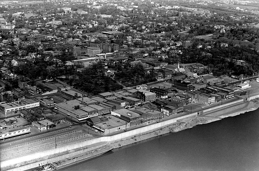
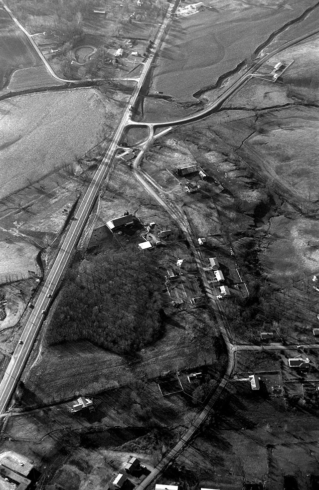
Our house was built in 1956, long before Kurre Lane was extended and longer yet before Station #4 was built, as you can see in this aerial photo I took in 1966. Our house was the first of the three houses going down the hill from Kurre, the street running horizontally at the bottom of the photo.

Mother loved having the station across the street

Mother loved having your guys across the street. If she got her lawn mower hung up in the ditch in front of the house, they’d help her get it unstuck. If she went to the store to buy a 50-lb bag of bird seed, she’d wait until she saw someone in the parking lot and ask them to help her get it out of the trunk.

Several years ago, she experienced shortness of breath that turned out to be congestive heart failure. I’m convinced that one of the reasons she didn’t hesitate to dial 9-1-1 was that she knew the folks who would respond.

Sirens were the last thing that bothered her

I smiled a bit when I read the question about the nuisance rating relating to the noise of sirens.

As a newspaper director of photography, I had to make sure all the paper’s police and fire monitors were capable of receiving new systems that were changing all the time. That meant I had a huge surplus of old radios that would find themselves in Cape. I think she had a scanner in every room but the bathroom, and she might have carried a portable in there.

As soon as she heard a siren go out from the fire station or the ambulance company, she’d fire up the scanner closest to her to find out what was going on. That gene is possibly what caused me to end up in the newspaper business.

The station was an asset to the neighborhood

Far from lowering property values, I’ve always told folks that it’s a tremendous asset to have you and the ambulance company within a block of us. I’m sure there is a priority given to keeping Kingsway Drive’s street clear of snow and ice, and on keeping the power on in our area because of it.

Oh, yes, we have NO trouble hearing the warning siren, even in the basement.

In 2013, my grandson Graham came to Cape from Florida to visit his great-grandmother. Of course, we had to go look at the fire trucks. He was impressed with the size of the apparatus, and dug “driving” it and blowing the siren, but he wasn’t quite ready for the sound of the air horn, as you can tell in one of the photos.

Mother led a full and active life for most of her 93 years, only having a quick decline after the first of 2015. I came to Cape to assist her.

You didn’t have to dial 9-1-1 when Station 4 was across the street

One night she tumbled out of bed, tearing her paper-thin skin. I didn’t think it was an injury worth going to the emergency room in the middle of the night, but I wanted a second opinion and help picking her up off the floor. Instead of dialing 9-1-1, it was nice to be able to walk across the street to describe the problem.

They did a truck roll, bandaged her up, and helped lift her. I couldn’t have asked for a better crew to show up. The fact that she recognized them helped calm her down and reassure her that everything was going to be OK.

She told me of the rumors that Station #4 was going to be replaced. If that’s the case, I’m glad she left before you folks did. She’d have been heartbroken to lose her good neighbors.

The night before the move to the new station

I kept telling myself that I should document the old station before it was too late. When I got around to it, the guys told me I had cut it close: this was their last night before the move.

Mike Smith, Mike McLemore and Byron Stroer were kind enough to give me the run of the place for a few hours.

The last hours of Station 4

Sometimes you throw aesthetics aside and shoot for the record. That’s what these photos do. Click on any image to make it larger, then use your arrow keys to move around. Note: there are two pages to the gallery. I didn’t notice that at first.

Turn Right to Downtown

General Sign for Cape DowntownThis General Sign Company invitation to “Stop ‘n Shop – Turn Right Foot of Bridge to Downtown Cape Giardeau takes us back to the day when Main Street was THE shopping area for the region. The photo is part of the collection Terry Hopkins loaned me from his dad’s job at General Sign Company.

The sign must have been located in East Cape since that’s the only place a “Turn Right” would make sense.

See the smokestacks?

General Sign for Cape DowntownWhen the picture is blown up, you can see two smokestacks off to the right, one of them puffing black smoke.

The cement plant would have been way off to the left, so these stacks must belong to the shoe factory and the power plant north of it. I’m not sure what the white building off to the far right would be. Click on the photos to make them larger.

Here’s what they would have found

Cape Downtown Aerial Photo from the 1960sIf our shopper had turned right, this is what they would have encountered. Follow this link to see other downtown stories. Here is a collection of links to stories about Main Street businesses and buildings.

The Stonewall’s Mass Grave

Mississippi River at Neely's Landing 10-20-2012I’ve noticed an unusual traffic bump on the stories I’ve done about Neely’s Landing and the horrific steamboat The Stonewall disaster that occurred in 1869. That prompted me to post an update that is more speculation than fact.

Here’s a little refresher. You can go to my original post for more detail.

  • Oct. 27, 1869, the steamboat The Stonewall, heavily laden with about 300 passengers, tons of cargo and 200 head of livestock was southbound on the Mississippi River near Neely’s Landing, bound for Cape Girardeau, Memphis and New Orleans. The river was low and the boat was running “slow wheel.”
  • A candle or lantern overturned or a passenger dropped a spark onto hay on the lower deck, which caught fire. Before the blaze was discovered, it had gained considerable headway.
  • The captain tried to beach the boat, but it struck a sandbar and turned in the wind and current until the flames fully engulfed the vessel. Nobody knows exactly how many people burned, drowned or died of exposure because the passenger list burned with the steamboat. Estimates place the toll between 209 to 300.
  • Some 60 or 70 unidentified or unclaimed victims were buried in a mass grave on the Cotter Farm.

A hunt for the grave site

Neely's Landing Cemetery 10-20-2012I spent quite a bit of time driving around Neely’s Landing searching for the grave site, but there’s not much left of what was once a thriving town. Mississippi River floods erased many buildings, much like they washed away Smelterville and Wittenberg. The Proctor & Gamble plant gobbled up even more of it.

I thought a cemetery high on a hill overlooking the landing might be a possibility, but I quickly dismissed it.

Here’s why I didn’t think it qualified.

Here’s another possibility

Aerial Proctor & Gamble 04-17-2011Amateur historian Dick McClard and I started trading ideas. He has forgotten more about that area than I ever knew because of his research into the McClard family and its many offshoots.

He thought that the old Cotter Farm and grave site might be on Proctor and Gamble’s property in the general vicinity of the X. It was on the Neely’s Landing side of Indian Creek; the ground was fairly flat and the soil was soft.

Dick was a former P&G employee, so he knew the right ears to blow into to get us an escorted visit to our target area.

We struck out

Stonewall gravesite panoramaThe security guard who was our ride and guide was on a tight schedule, so we didn’t get much time to nose around. I had time to shoot a nearly 360-degree panorama of the general area that didn’t show anything particularly interesting. The left side of the photo is looking north, then it swings to the right until we are looking approximately north-northwest.

You’ll have to click on the photo to make it large enough to make out anything.

Dick thinks that any markers that might have existed were moved or covered over when the railroad cut through the area to carry visitors to the 1904 World’s Fair in St. Louis. Decades of Mississippi River and Indian Creek floods probably scoured the area, plus it has been farmed.

We’re going to give it another shot, but timing is critical. It’ll help if we get there before the brush, snakes and bugs start showing up after wintertime. The best we can hope for would be some discarded stones or markers that have been pushed off to the edges of the property, but I doubt there was much around to set the graves off from the surrounding farmland.

Here’s one of the best accounts I’ve run across about the disaster and the history of the area.


Fire Station No. 4 Missing

Mary Steinhoff Kingsway DrWhen I looked at this old Polaroid photo of Mother, I thought there was something odd about it. Then it dawned on me: it was taken before Fire Station No. 4 was built at the corner of Kingsway Drive and Kurre Lane.

(If you wonder how I knew it was a Polaroid, look at the brown, irregular stain at the bottom right of the photo. This was one of the early generation cameras where you had to peel the photo off the roll, then coat it with a sticky, sharp-smelling chemical which would, invariably, get all over your fingers. The fix or whatever it was never applied evenly, so the picture had streaks, and if you missed a place, you’d get this brown stain.

Neighborhood from the air

Kingsway Drive with Cape LaCroix Creek at top 1966Here’s an aerial photo taken at about this same time. I published it and some other pictures back in 2010, and it got lots of comments that are worth reading. There’s a more recent aerial here.

Click on the photos to make them larger.