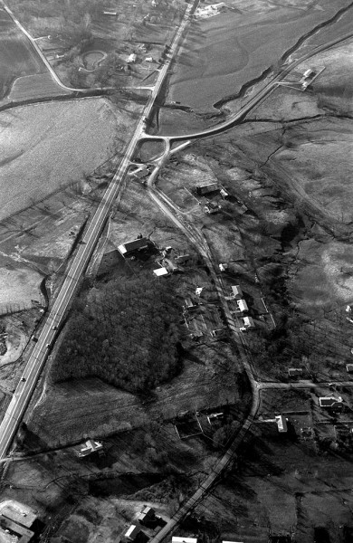
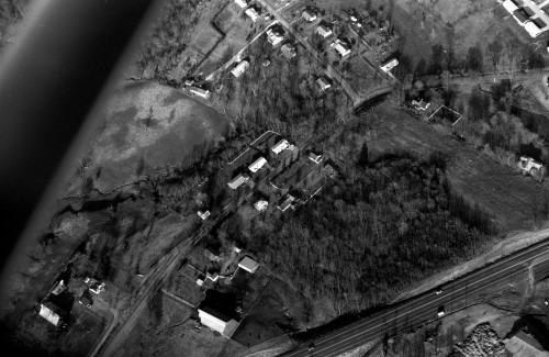
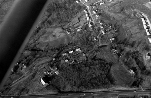
 Most photographers I’ve known will always try to sneak in a couple frames of their homes when they’re up shooting aerials, and I’m no exception. Here are some shots of the 1600 block of Kingsway Dr., Kingshighway and Kurre Lane neighborhood from about 1966.
They were taken late in the afternoon when the leaves were off the trees. The sidelighting gave excellent modeling to the terrain.
Cape LaCroix Creek
In the photo above, you can see Cape LaCroix Creek – better known to us kids as 3-Mile Creek – meandering through its flood plain. What we used to call Old Jackson Rd. curves in to connect with Kingshighway at a 90-degree angle. This was shortly after the intersection had been changed to conform with modern standards. Up until then, it connected with the highway at an angle, which is still visible.
The trailhead for the Cape LaCroix Recreational Trail is located there now.
Outside the city limits
 When the Steinhoff family moved to 1618 Kingsway Dr. in 1954, we were one of the first three “modern” houses in the block. We were the house closest to Kurre Lane of the three homes in the center of the frame. Today, the neighborhood is not only inside the city limits, but population and boundary shifts have put it in the center of Cape.
There was a heavily wooded area between our house and the corner that belonged to Dennis Scivally, Cape Special Road District Engineer, for whom Dennis Scivally Park was named. Dad started trimming out the small trees and brush on the lot and eventually bought it.
It had a big old walnut tree that was perfect for building a tree house. Why my buddies and I didn’t get killed building it is a wonder to me today. On windy days, I’d climb as high as I could in the tall, spindly trees, jam myself in a fork and sway three or four feet for hours at a time.
At some point, Dad and Mother sold a piece of the property to the McElreath family, which owns it today. They built a home on the corner, which took out my tree house.
Try this persimmon, you’ll like it
There was also a big persimmon tree that would drop tons of the sweet fruit in the fall. It was always good for a laugh when you could persuade some unsuspecting kid to bite into a green persimmon. If you don’t know what I’m talking about, I’m sure I can find some in time for the reunion.
Cows in our back yard
 There were two working farms with big barns on our street – the Hales and the Heislers. We had cows in the field behind our house.
The Tinkers lived directly across the street from us. After they moved out, Bill and Rhonda Bolton bought the house. They’ve made a bunch of improvements to the house and they’ve been great neighbors who keep a close eye on my mother.
John and Mary Gray lived in a house that he had converted from an old chicken coop. They had a big garden between them and the Tinkers. The Rose family lived in a two-story house in front of them. Two house down from us lived the Garners. The house between us and the Garners has had a variety of owners over the years. The Ailor family lived there when this photo was taken.
Kurre Lane dead-ended at Kingway in 1966. There was no fire station, Girl Scout office, or funeral home in those days. Traffic was light enough that my brothers and I could pile into our little red wagon and coast all the way down to the bottom of the hill without fear of getting run over.

Ken, I seem to always pre-date your posts by abut 8 to 10 years. After returning in 1956 from serving 2 years in Germany with the U.S. Army I entered SEMO U on the GI Bill. One of my part time jobs was working in the Paul Rau orchard, north of Cape, processing the peach crop. My uncle managed the farm for Paul and Jean Rau who lived in Centralia IL where Paul was a Professor in the University (?) close there. I got to know one of the young ladies also working there. Barbara Heisler and I dated for a time. She and her mother were working at the peach processing shed. (BTW I wish you or someone had pictures or ? on the Paul Rau orchard). Paul’s family were early immigrants to the Hanover Church community and some of the present Heuer families are the descendants. The orchard is now gone and few remember the orchard and its operation on CR 620 with the orchard location on CR 638. Barbara had a brother Charles who died early in his 30’s I believe. I do remember their house and barn. Their driveway entered off Kingsway and came up in front of the house which faced east. Barbara drove a nice car, seems like a pink or light red 1955 or so Chrysler with the high tail fins. I loved that car. We enjoyed the drive-in movies at the Starvue. Their house may still be there, however the barn is gone. It was located, as I remember, near the present location of the Rhodes 101 station. Others who worked in the peach processing shed were Jerry Schlegel, Don Seabaugh, Agnes Foeste, the Arthur Krueger girls, Althea, Dorothy and Arlene, my cousins, my sister Arlene and many others. Bert Heuer and Harold Phillips hauled the picked peaches from the orchard to the shed. — Just a bit of history that very few now remember —.
I don’t think there’s anything left of Heisler’s place anymore. I don’t see any remains when I click on the Google Maps link for a larger map and zoom in.
I tried to call my mother to confirm that everything had been torn down, but she was away. I’ll check with her later.
The orchards around Cape and Jackson are quickly becoming memories. Johnny Housing Developer has replaced Johnny Appleseed, unfortunately.
Ken – To think of the times I biked by your house in the late 50s without knowing it. With my trusty fishing rod en route to a few small holes in “three mile creek”. The stream was tree-lined then, and not cleared along the old Jackson road as in the ’66 photo. I remember the stir caused by the overflow of Dr. Seabaugh’s (I believe it was) farm pond which dumped a lot of “keepers” into the little creek. Wish I had grown up with cows in my back yard, rather than the SEMO Hospital which eventually gobbled up my boyhood home for expansion.
Larry,
The stretch of the creek at the bottom of Kingsway was always pretty clear, as I remember it. If you went upstream, then it got more grown up. I liked fishing the stretch around the old iron bridge and just upstream of it.
This was the bridge after it was replaced.
One day a couple of my buddies and I decided we would hike to the very start of Cape LaCroix creek. It took us most of the day, but we finally came to a gully on the side of a hill that we deemed to be the headwaters of 3-Mile Creek.
For some reason,we never explored too far to the south.
I can’t remember the name, but the go-kart track can be seen in the upper left hand corner. It is now an office building and Elias Hardware.
Before that, there used to be a guy who would set up a big tent with tables at that corner in the summertime to sell ice-cold watermelon by the slice.
The only time I can recall better watermelon was when Dad had a gravel plant set up in the creekbed near Egypt Mills. A farmer came by and offered to sell a whole truck of watermelons for $10. Dad took him up on the deal, and work stopped while the whole crew pigged out on watermelon hearts until we could hardly waddle.
Do you by chance have any photos like this showing a bit further to the east? My husband and I bought a house on Melrose Ave. about 5 years ago. As you turn on Melrose from Kurre, ours is the fourth house down on the right. We have often wondered how our current neighborhood came to be and what houses came first. Your stories about our “new” neighborhood are great to read! Also, any ideas on how to find the history of a house? When built, by whom, how the floor plan was origionally laid out? Perhaps one of you on here remember?
I’ll keep my eye open for you, Stacey, but you have to remember that there wasn’t much out there in the days when I was shooting photos.
That was part of my paper route when I was a kid and I think there might have been all of about three or four houses on the street in 1959-1960.
There are some folks from the Cape County Archives hanging out here. Maybe they could give us all tips on the best way to research property records.
If you go to Google Earth, it has a historical timeline feature that will let you see overlays from all of the aerials they have of an area. The earliest photo of Melrose was taken Mar. 10, 1993; the most recent was Aug. 12, 2009.
After high school my parents bought a house on Riverside Drive just off of Kingsway. It was the third house to be built on the street and was a Riverside Lumber Co. display home. Across the street was the KFVS Dream Home. My husband and I bought the house from my parents and we are still there. My kids grew up in this neighborhood and it was awesome for them. Lots of dead end streets. They also would take a blow up boat and put it in the Three Mile Creek or LaCroix after a big rain and float. Usually this was done unbeknownest to their mother…me! Our house was built in 1963…will try to find it on the map.
In the third black and white picture I think my house is in the upper right hand corner dark roof. In the google map it is the fourth house but can’t really see it because we have 4 huge pin oak trees in the yard!
That might be it, then. Sorry I don’t have any other frames from that neighborhood (that I’ve found yet).
Fascinating photos! Anyone know when the houses on David St., between Leroy and Melrose, were built?
Drew,
That street was on my paper route when I was 12-14 years old, which would have put it about 1959-1961.
http://www.palmbeachbiketours.com/50-years-and-the-hills-have-gotten-steeper/
The streets had houses on them, but they weren’t that old. I’m going to guess they probably went up in the early to mid-50s.
Ken, we lived in the Kurre house on Kurre Lane. I was 6 months old when we moved there from Themis Street in 1957. My older brothers Larry & Jim remember the neighborhood better than I and Jim was always fishing at 3 mile creek. The Nolans lived on the corner of Kurre and Kingsway and Ann Nolan had a beauty shop in the basement. We picked blackberries by the bucket full near what is now Lexington. That area was all woods and farmland. We moved to a house Dad built on Lyndhurst in 1962. Huntington was a gravel road then.
Three mile creek “Good old swimming hole”
The go-kart track was own bt Elmer Luering