Road Warriorette Reactions

NN north of Bertrand 12-03-2015All of my road warriorettes display different reactions to my driving. Foodie Jan is prone to scream “We’re all going to die!!!!” at the least provocation. She’s also the one most likely to question my food and lodging choices.

Curator Jessica is so young she still thinks she’s immortal, so she takes my driving quietly.

You haven’t heard much about Warriorette Anne lately because she abandoned me for Texas. She kept quiet even when she had good reason to scream. It was on that occasion that Mother, the original Warriorette, said she didn’t scream because she was biting down too hard on a pillow to keep from doing it.

(You can click on the photos to make them larger.)

Now that I think of it

Suspension pipeline from Grand Tower IL 07-17-2011I only knew of one time when Mother expressed any kind of shock.

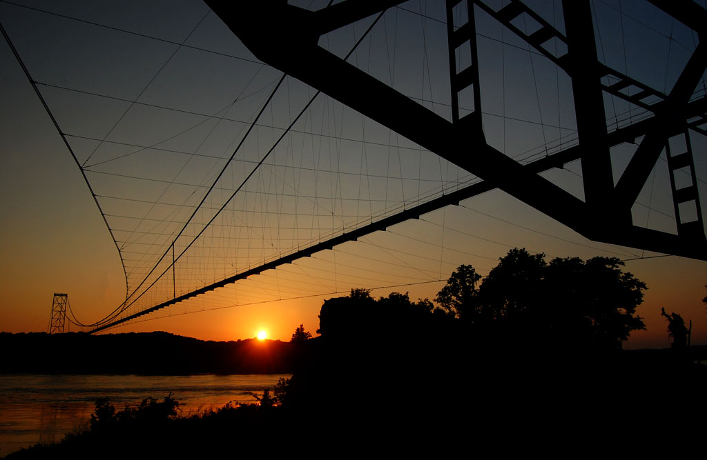
I was trying to get a good photo of the world’s longest suspension pipeline that links Wittenberg, Mo., with Grand Tower, Ill. I had been there about an hour earlier and got some nice pictures, but after heading north along the river and not finding a good angle, I decided to race the sun back for this shot. I made it with about five minutes to spare. When I went airborne over the top of a levee, Mother yelled, “Whoa!

I knew there was a road on the other side of the levee, but she, evidently, didn’t.

At the time, I wrote, “She never yells, ‘Whoa!’ She yells, ‘Gun it!’ She must be getting old.”

Getting to the point of the picture

NN north of Bertrand 12-03-2015
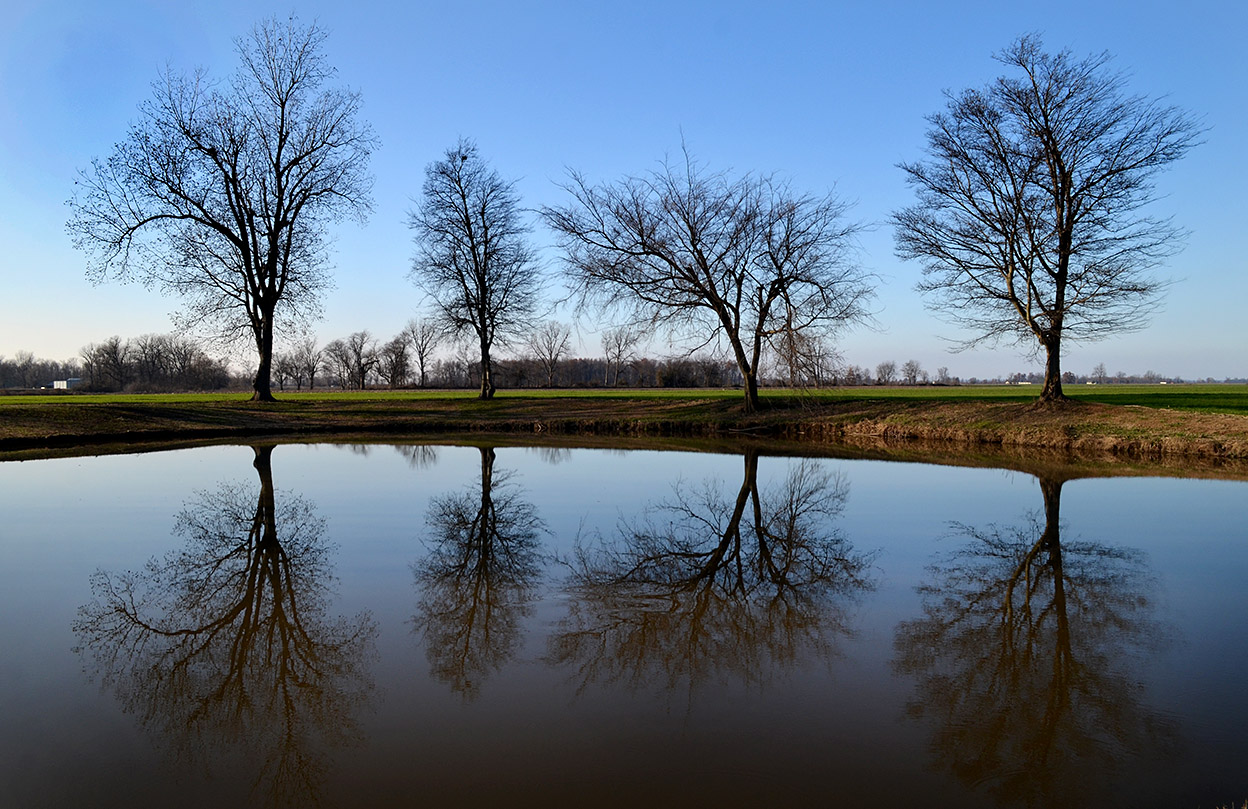
Getting back to the original subject of the tree photo at the top of the page: Warriorette Shari, my old high school girlfriend (briefly, by her choice), and I were hammer down on NN north of where I took the silo picture when I smoked the brakes and did a sliding U-turn. Shari didn’t say a word, even when I pulled off on the side of the road and jumped out.

I had spotted a farm pond that was perfectly smooth and picking up the reflection of trees backlit by the setting sun. It captured the feel of The Bootheel for me: the endless flat ground, the green crops, the trees and buildings way off in the distance.

When I crawled back in the car, I tried to explain my philosophy of “Shoot It When You See It” because I was losing the reflections of the trees in the three or four minutes it took me to get turned around and start making exposures.

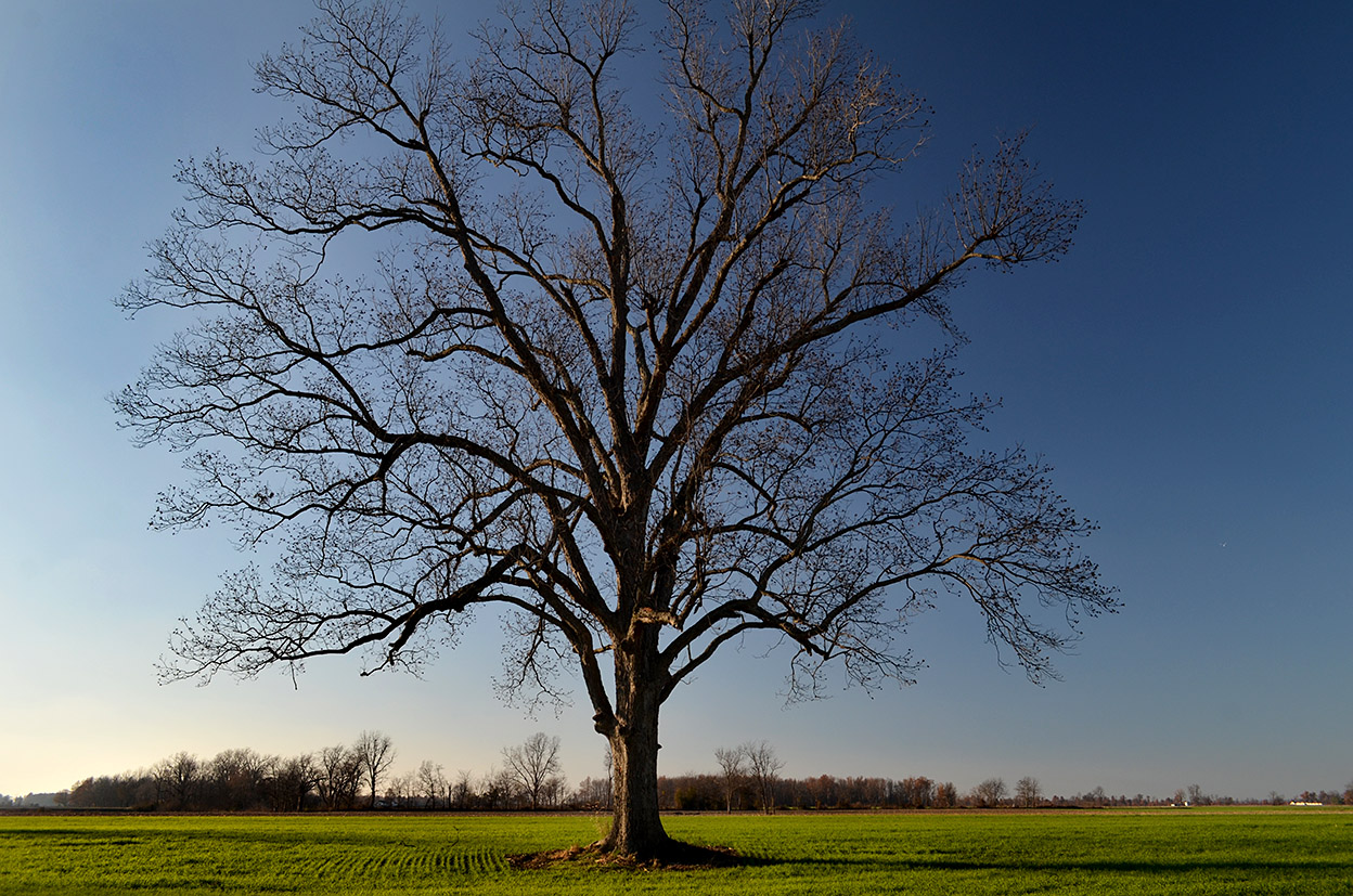
This old tree standing sentinel in the field has the same feel as the pond photo, but I like the reflections better in the first shot.

I almost always use a circular polarizing filter on my lens to protect it, reduce reflections and make skies more dramatic. Depending on the angle of the light, sometimes it doesn’t work at all or, like here, it causes part of the sky to be a different shade, which bothers me.

Tower Rock Quarry Exposed

When this aerial photo of Tower Rock was taken April 17, 2011, the river gauge in Cape was at about 43 feet and heading higher. The half-moon bay downstream and to the right of The Rock was a big circular corn field until the Flood of 1993, Gerard Fiehler of the Altenburg Lutheran Heritage Center and Museum said. The flood created a huge scour basin that’s a good 25 or 30 feet deep and several football fields across. Trees that grew along the basin are probably in the Gulf of Mexico today.

Click on any photo to make it larger.

We climbed Tower Rock in 2003

Brother Mark and I climbed to the top of Tower Rock in 2003. When the river stage in Cape is about six or seven feet, it’s possible to walk across to the rocky island. (It’s about 14 feet and falling on Nov. 7, 2011)

BE CAREFUL.  If the water’s more than a few inches deep, it can sweep your feet right our from under you. Missionary Father Marquette, who explored the area by canoe in 1673, said the “savages” believed Tower Rock to be “the demon that devours travelers.”

This view to the south shows the remnants of a quarry that was worked off and on for 135 years until almost all of the rock was exhausted in 1972. At normal river levels, only a little rock, if any sticks out of the water.

Low water uncovers artifacts

Despite the tremendous volume of water that sweeps over the area even in normal times, traces of track and tipple car wheels survive. These wheels could date to the late 1800s, Tower Rock, a book distributed by the Perry County Historical Society, says. The author thinks they may have been buried until the 500-year floor of 1993 uncovered them.

Acme Stone Crusher survives

Tower Rock identifies this rusting metal object as a steam-powered Acme rock crusher. A similar or the same crusher was used across the river in Grand Tower in the mid 1870s.

Steamboat tieup

Not far from the crusher is this dual-ring steamboat tieup. There are several different styles on the jetty, the  oldest dating to the 1830s to 1850s. The quarry was most active from the Civil War through the Great Depression.

Now’s the time to see Tower Rock Quarry

If you’re going to go, go while the weather is nice and the river is low. This opportunity doesn’t come often.

Tower Rock isn’t some place you stop on the way to somewhere else. You have to REALLY want to go there. You start by passing through Altenburg on Missouri Hwy A. (It’s worth stopping at the excellent Lutheran Heritage Center and Museum. In fact, I printed a couple dozen scenic photo books for their gift shop to sell to gauge if there’s a demand for them. They’re going for $14, a steal.)

Might be longest suspension pipeline in world

After going up and down some steep hills, just before you get to what’s left of the German pioneer village Wittenberg (Population: two buildings and three people), you’ll see a small sign off to the right pointing to Perry County 460, a steep and washboarded gravel road. As you drive along that road, you’ll spot what may still be the longest suspension pipeline in the world, that carries gas from Texas to Chicago. Not far from there, the road narrows and you pass through an area of fallen trees. I’ve spotted a momma deer and her two fawns twice on this stretch.

Stop, Look and Listen

Now things get interesting if this is your first trip. You’ll make a sharp 90-degree bend to the left and cross over the BNSF railroad tracks and make an immediate right-hand 90-degree turn paralleling the river. After not seeing any trains at the crossing for years, two have passed on my last two visits: Stop, Look and Listen.

The stretch along the river is narrow and there’s a steep drop-off to the water, but you seldom meet a car. Eventually, you’ll come upon a parking area at the Tower Rock Natural Area, donated by Mr. and Mrs. Charles Bussen to the Missouri Conservation Department.

If there are any persimmons left, give them a try. You won’t find any anywhere else that are sweeter.

Shameless Plug: Buy My Book

{Shameless Plug: don’t forget to stop in at the Altenburg Museum to pick up a copy of my Tower Rock book. The museum folks are nice and they’re going to be setting up their Christmas Tree exhibit in the next week or so. It’s worth seeing.]

UPDATE: The Tower Rock book is now out of print.