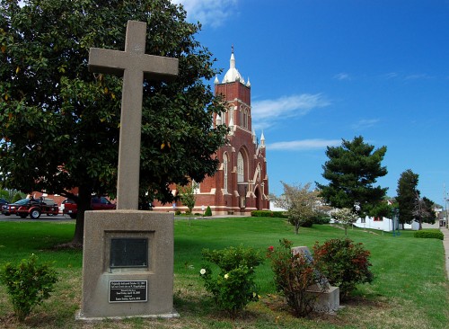
 As long as I can remember, a simple concrete cross stood at the intersection of Kingsway Drive and Kingshighway. I have to admit that I knew it had to do with something historical, but I wasn’t exactly sure what.
Still, it disturbed me that something that had been a Cape Girardeau landmark since 1947 would be displaced in 2009, so a commercial building could be built and some public land swapped around.
I was looking for a couple of other landmark monuments Thursday when I ran across my old friend, the cross, at the corner of William and South Main, on the grounds of the St. Vincent de Paul Catholic Church.
Cross relocated on Good Friday
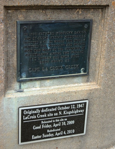 A new plaque says the monument was originally dedicated Oct. 12, 1947 at the LaCroix Creek site on N. Kingshighway. Relocated to this site on Good Friday, April 10, 2009 and rededicated Easter Sunday April, 4, 2010.
The original plaque says, “In 1699, Fathers Montigny, Davion and St. Cosme, French missionaries, erected a cross where this stream entered the Mississippi and prayed that this might be the beginning of Christianity among the Indians. The stream has ever since been known as Cape La Croix Creek.”
I find it interesting that one monument could have two different spellings for the name of the stream that it recognizes: Cape La Croix Creek and LaCroix Creek.
Kingsway and Kingshighway 1966
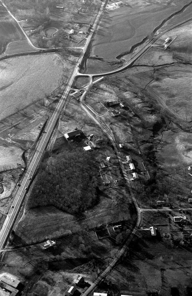 Kingshighway is on the left. Kingsway is on the right. At one time, the road that went by the names Old Jackson Road and 3-Mile Creek Road met Kingshighway at a 45 degree angle. State guidelines required that intersections should meet at 90-degrees, so the road was curved slightly to the west.
The monument was located in the dark brush area just west of the old intersection of Old Jackson Rd. and Kingshighway.
The area has changed drastically. Kurre Lane, at the bottom right, has been extended to Kingshighway and a fire station sits on the corner. The two farms and their barns have been torn down. The cow pastures we used to look over have homes planted on them.
Cross on St. Vincent’s grounds 2011
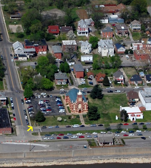 The cross now lives on the southeast corner of the St. Vincent de Paul Catholic Church grounds (marked by the yellow arrow). The Red House is at the bottom of the photo and the Jewish Synagogue is the white building with red trim on the lower right.
If the original intent was to mark the meeting of Cape LaCroix Creek and the Mississippi River, I guess the new location is probably about as close to the actual spot as the 1947 location.
Still, it bugs me that a landmark was uprooted for what appears to be someone’s commercial gain.
UPDATE Kingsway-Kingshighway in 2010
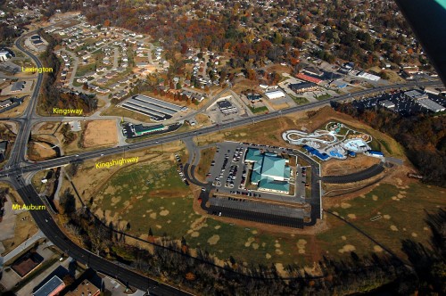 Some folks asked what’s at the Kingshighway-Kingsway intersection today.
Here is an aerial photo I shot Nov. 6, 2010. It’s almost easier to list what’s NOT there. A Plaza Tire store is about where the cross stood. The large building complex at the bottom is the Osage Center; the new water park was under construction to its right. Storage units and a housing development cover what used to be two farms and their fields.

Haven’t been to Cape for awhile but not because of my lack of desire. I’m curious as to what has happened to the site where the cross stood. It will not seem normal without the cross.
I updated the post with an aerial photo I shot in November 2010.
You might have to hit Ctrl-F5 to refresh your browser to see the addition.
The old aireal photo shows how rural we were in 1966. Mt. Auborn road must have been built between ’66 and ’67. I remeber it in the spring of “67, it was a gravek road. In the upper left corner I can see the old Windmill go-kart track and miniture golf park
Back in the late 1990’some people objected to the location of the cross as a symbol on public property. As the issue went on it was decided that the cross should be moved to private property. It was relocated to St. Vincents, at the corner of Main and William as it commemorated the exploration and temporary settlement of ‘the Fathers'(Des Peres…the town in St. Louis is named after them). Fathers Davion, Montigny and St. Cosme (the creek near Perryville is named after him).
Thanks for the mention of the Red House Interpretive Center which is in the foreground of the bottom picture. The center was under construction from 2001-2003 and has been open since the Lewis and Clark bicentennial celebration in Cape Girardeau in November of 2003 and depicts the period of Louis Lorimier’s life in the area. The Red House was made possible by two grants a construction from the state and one from the Lewis and Clark Bicentennial Foundation to cover the cost of exhibits, lots of effort from many dedicated volunteers and the vision of local historians. It is managed by a board of directors, operated by loyal docents, and maintained by the Cape Girardeau Parks and Recreation Department. Hours are Saturday from 10-4 beginning April 30. Call the Convention and Visitors bureau to arrange group tours.
Thanks Ken for the 1966 photo of the old neighborhood. You didn’t mention your home and I forget which one of the three homes on the right side of Kingsway you lived. I believe the school bus also picked up the Garner boys whom I assume were your neighbors. These thoughts go back to the late 1950s when we lived on Grandview Dr. I believe the two roofs at the bottom of the photo that you can see partially, are homes starting up the hill on Grandview Dr. Many, many times I rode on my bike out Kingsway, past your home, to fish in Cape La Croix Creek. The cross was such a permanent welcome site to coming home to Cape. By 1966 when you shot this photo, my family had moved to Allendale Dr and I was gone from Cape. Thanks again for the update.
But one is never far from Cape, yesterday I was in a meeting and had lunch with Norman Baker, Asst Fire Chief from Cape in Saint Louis. It was fun learning from Norm, what is happening in Cape. It was good to learn that three of my classmates and retired Cape firefighters, Max Jauch, Red Allen and Bob Thompson are doing well.
My mother still lives in the house nearest Kurre of the three that are clustered together. She’s the only resident that’s been here since the start. The Garner family lived in the third house down the hill.
Here are some more shots of the neighborhood.
Curious to know what that one house is among all the tarmac in front of the church in St. Vincent’s shot. One house, small patch of green all around it. The rectory of the church?
Jan,
It’s the Red House that Linda Nash describes. It’s a remake of the house Cape Girardeau founder Louis Lorimier lived in on this corner.
The Red House and the first St. Vincent’s Catholic Church were destroyed by a tornado, if memory serves me.
Here is a video I made of the cross relocation April 10, 2009:
http://www.youtube.com/semissourian#p/u/132/q5jEpw7WQCw
Nice to see a pic of old St. Vincents. Went to elementary school at St. Vincent’s Elementary which was adjacent to the church. Played a lot of softball and basketball on that blacktop now used for parking.